GENERAL SITUATION: A weak ridge of high pressure is maintaining gentle easterly breezes and generally stable conditions across the Turks and Caicos Islands today.
SPECIAL WARNINGS: There are currently no watches or warnings in effect at this time.
The public is advised to remain hydrated, wear protective clothing and sunscreen, and seek shaded areas while outside during peak sunshine hours (11am – 4pm), as UV indices are expected to be in the very high to extreme range, and the heat index possibly reaching the triple digits across all areas.
ALL AREAS
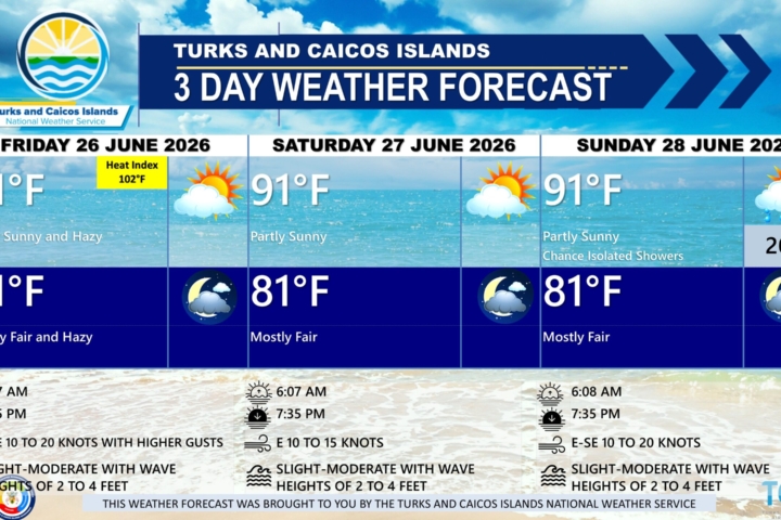
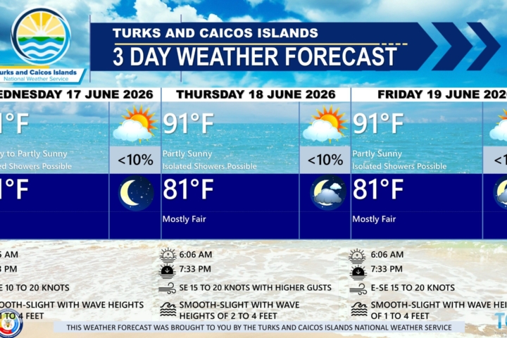
WEATHER: Mostly sunny today. Mostly fair with isolated showers possible tonight.
WINDS: Easterly at 5 to 15 knots
SEAS: Slight to moderate with wave heights of 2 to 4 feet
DAYTIME HIGH TEMPERATURE 91°F 33°C
HEAT INDEX 102°F 39°C
OVERNIGHT LOW TEMPERATURE 81°F 27°C
SUNSET: 07:35 PM
NEXT LOW TIDE: 02:48 PM (0.7 FT)
NEXT HIGH TIDE: 09:20 PM (3.0 FT)
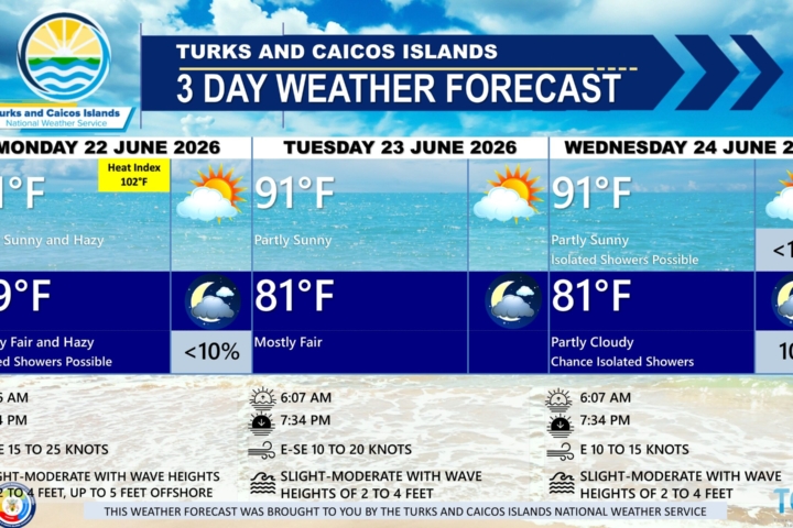
EXTENDED FORECAST: Generally stable conditions will persist through today. The high pressure ridge will gradually weaken, with a developing surface trough possibly triggering isolated showers across the islands by Tuesday. A plume of Saharan dust is then expected to move into the region by late Wednesday, likely suppressing shower activity.
TUESDAY: A low (10 to 20 percent) chance of isolated showers. Partly cloudy, with a high near 90°F (32°C).
TUESDAY NIGHT: Isolated showers possible. Mostly fair, with a low around 80°F (26°C).
WINDS: East to southeast at 10 to 15 knots
SEAS: Slight to moderate with wave heights of 2 to 4 feet
SUNRISE: 06:09 AM
SUNSET: 07:35 PM
LOW TIDE: 03:42 AM (1.0 FT) 03:24 PM (0.7 FT)
HIGH TIDE: 09:21 AM (2.3 FT) 09:56 PM (3.0 FT)
WEDNESDAY: Isolated showers possible. Partly sunny, with a high near 90°F (32°C).
WEDNESDAY NIGHT: Mostly fair, with a low around 80°F (26°C).
WINDS: East to southeast at 10 to 15 knots
SEAS: Slight to moderate with wave heights of 2 to 4 feet
SUNRISE: 06:09 AM
SUNSET: 07:35 PM
LOW TIDE: 04:16 AM (1.0 FT) 03:59 PM (0.7 FT)
HIGH TIDE: 09:55 AM (2.3 FT) 10:32 PM (3.0 FT)
TROPICAL WEATHER OUTLOOK: Disorganized showers and thunderstorms located off the southeastern U.S. coast are associated with an area of low pressure along a frontal boundary that has a low chance of tropical cyclone formation within the next seven (7) days.
FORECASTER: DR. H.HAMILTON