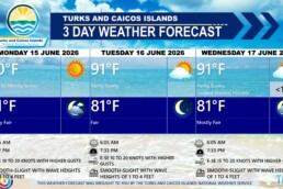
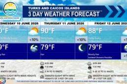
PUBLIC FORECAST FOR THE TURKS AND CAICOS ISLANDS FOR THE NEXT THREE DAYS FROM WEDNESDAY JUNE 17TH 2026
GENERAL SITUATION: High pressure ridging will maintain generally stable weather and breezy conditions across the Turks and Caicos Islands.
SPECIAL WARNINGS: No special warnings at this time.
ALL AREAS
WEATHER: Mostly to partly sunny with isolated showers possible near the coastline today. Fair tonight.
WINDS: Southeasterly at 10 to 20 knots
SEA STATE: Smooth to slight with wave heights of 1 to 4 feet
DAYTIME HIGH TEMPERATURE 91°F 33°C
HEAT INDEX 102°F 39°C
OVERNIGHT LOW TEMPERATURE 81°F 27°C
SUNSET: 07:33 PM
NEXT LOW TIDE: 04:49 PM (0.3 FT)
NEXT HIGH TIDE: 11:23 PM (3.0 FT)
EXTENDED FORECAST: Hot and humid conditions with breezy conditions are expected to persist through the remainder of the week. Daytime heating may trigger isolated showers at times across the islands.
THURSDAY: Isolated showers possible in the afternoon. Partly sunny, with a high near 91°F (33°C).
THURSDAY NIGHT: Mostly fair, with a low around 81°F (27°C).
WINDS: East to southeast at 15 to 20 knots with higher gusts
SEAS: Smooth to slight with wave heights of 2 to 4 feet
SUNRISE: 06:06 AM
SUNSET: 07:33 PM
HIGH TIDE: 05:50 AM (0.7 FT) 05:42 PM (0.3 FT)
LOW TIDE: 11:31 AM (2.3 FT)
FRIDAY: Isolated showers possible in the afternoon. Partly sunny, with a high near 91°F (33°C).
FRIDAY NIGHT: Mostly fair, with a low around 81°F (27°C).
WINDS: East to southeast at 15 to 20 knots with higher gusts
SEAS: Smooth to slight with wave heights of 1 to 4 feet
SUNRISE: 06:06 AM
SUNSET: 07:33 PM
HIGH TIDE: 12:14 AM (3.0 FT) 12:27 PM (2.3 FT)
LOW TIDE: 06:40 AM (0.7 FT) 06:39 PM (0.3 FT)
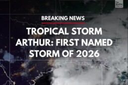
TROPICAL WEATHER OUTLOOK: Tropical Storm Arthur has developed near the middle Texas coast. See the latest news item on Tropical Storm Arthur from the Bahamas Department of Meteorology. Elsewhere, tropical cyclone formation is not expected during the 7 days.
FORECASTER: H. HAMILTON