POORLY ORGANIZED FRANKLIN APPROACHES HISPANIOLA…
At 500 PM EDT, the center of Tropical Storm Franklin was located near latitude 15.8 North, longitude 71.4 West, or about 390 miles south of Cockburn Town, Grand Turk, Turks and Caicos Islands.
Tropical Storm Franklin is moving toward the northwest near 7 mph. On the forecast track, the center of Franklin is expected to approach the southern coast of Hispaniola tonight, cross the island on Wednesday, and then and then pass east of the Turks and Caicos Islands late Wednesday into Thursday.
Maximum sustained winds are near 40 miles-per-hour with higher gusts. Some strengthening is forecast before Franklin reaches Hispaniola. Little change in strength is forecast during the next couple of days while Franklin moves near and across Hispaniola.
Franklin is a poorly organized system and there is uncertainty in Franklin’s path as it comes off Hispaniola, therefore a Tropical Storm Watch remains in effect for the Turks and Caicos Islands.
Residents in the Turks and Caicos Islands should closely monitor Alerts issued by the Turks and Caicos Islands National Weather Service and Department of Disaster Management & Emergencies and begin to make preparation for the possibility of tropical storm conditions beginning late Wednesday night.
HAZARDS AFFECTING LAND
———————-
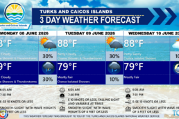
WIND: Tropical storm conditions are possible in the Turks and Caicos Islands beginning on Wednesday night.
RAINFALL: Franklin is expected to produce rainfall amounts of 1 to 2 inches across the Turks and Caicos Islands, with isolated higher amounts up to 4 inches in the islands of South Caicos, Grand Turk and Salt Cay on Wednesday. Heavy rains can produce localized flooding of roads, properties, and communities.
SWELLS: Swells generated by Franklin can produce wave heights of 8 to 12 feet beginning Wednesday night. These swells will continue to spread westward across the area into Thursday. These conditions could cause life-threatening surf and rip current conditions.
RECOMMENDATIONS TO THE PUBLIC
———————-
Here are a few precautionary measures and recommendations for the public to follow:
Stay Informed: Use this time to download the DDME Alert App for significant weather alerts and useful information on preparing for various hazards. Click the link: http://onelink.to/qe7vn2
Continue to monitor the DDME website and the TCINWS & DDME Social media pages for official weather updates.
Stock up on Emergency Supplies: Ensure you have an emergency supply kit ready, including non-perishable food items, drinking water, medications, flashlights, batteries, battery-powered radio, and essential supplies for infants or elderly family members.
Reinforce Your House and Business Structure: If you still need to complete this task, take the time now to strengthen your home and businesses against storm conditions. Prepare yourself well in advance for potential severe weather impacts.
Follow Official Guidelines: Follow the instructions and guidelines provided by local authorities. Do not disregard official advice and take necessary precautions to protect yourself and your family.
Next complete advisory at 0600 PM EDT Wed