GENERAL SITUATION: A weak pressure gradient is maintaining light winds and generally quiet conditions across the Turks and Caicos Islands today. However, prefrontal activity ahead of an approaching cold front could trigger a few showers overnight.
SPECIAL WARNINGS: No public warnings in effect at this time.
ALL AREAS
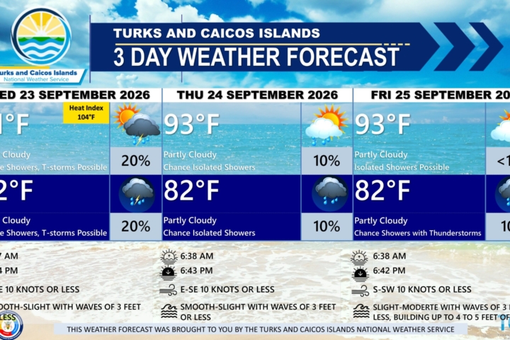
WEATHER: Partly cloudy with isolated showers possible today, then a low (10 to 30 percent) chance of showers tonight.
WINDS: Southwest to west at 10 knots or less
SEAS: Smooth to slight with wave heights of 3 feet or less, building up to 4 feet offshore
DAYTIME HIGH TEMPERATURE 93°F 34°C
HEAT INDEX 104°F 40°C
OVERNIGHT LOW TEMPERATURE 81°F 27°C
SUNSET: 06:42 PM
NEXT LOW TIDE: 02:04 PM (0.7 FT)
NEXT HIGH TIDE: 08:15 PM (2.6 FT)
EXTENDED FORECAST: The cold front will stall near the Central Bahamas on Saturday, bringing cloudy skies and an increased chance of showers across the Turks and Caicos Islands through the weekend. Conditions are expected to improve by Monday as the front weakens and high pressure builds across the area.
SATURDAY: Partly cloudy with a low (30 percent) chance of showers with isolated thunderstorms. Highs near 91°F (33°C)
SATURDAY NIGHT: Partly cloudy, with a low (10 to 20 percent) chance of showers. Lows around 79°F (26°C).
WINDS: South to southwest at 5 to 15 knots
SEAS: Smooth to slight with wave heights of 3 feet or less, building up to 4 feet offshore
SUNRISE: 06:38 AM
SUNSET: 06:41 PM
LOW TIDE: 02:28 AM (0.7 FT) 02:54 PM (0.7 FT)
HIGH TIDE: 08:38 AM (2.6 FT) 08:56 PM (2.6 FT)
SUNDAY: Partly cloudy, with a low (10 to 30 percent) chance of showers. Highs near 91°F (33°C)
SUNDAY NIGHT: Partly cloudy, with isolated showers possible. Lows around 79°F (26°C).
WINDS: South to southwest at 5 to 15 knots, falling light and variable at times.
SEAS: Smooth to slight with wave heights of 3 feet or less in the Caicos Bank; slight to moderate with wave heights of 4 to 6 feet in Atlantic waters.
SUNRISE: 06:38 AM
SUNSET: 06:40 PM
LOW TIDE: 03:06 AM (0.7 FT) 03:43 PM (0.7 FT)
HIGH TIDE: 09:23 AM (3.0 FT) 09:37 PM (2.6 FT)
TROPICAL WEATHER OUTLOOK
Active Systems:
Tropical Storm Fay is located well to the west-southwest of the Azores. Some strengthening is expected overnight before weakening likely commences by Friday afternoon or evening. A generally westward motion with some decrease in forward speed is expected over the next few days.
Tropical Storm Gonzalo is located east-southeast of the southernmost Cabo Verde Islands. The center will pass near or over portions of the Cabo Verde Islands today and tonight. Some strengthening is possible today, with a gradual weakening trend forecast to begin this weekend.
Tropical cyclone formation is not expected in the next 7 days.