
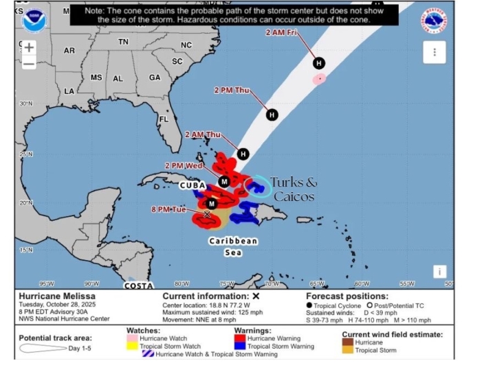
Hurricane Melissa a Category 3
Hurricane Melissa is now moving toward eastern Cuba. Conditions from Hurricane Melissa expected to deteriorate rapidly over the next several hours. Feeder bands of hurricane Melissa presently impacting the southeast and central Bahamas.
A Tropical Storm warning is in effect for the Turks and Caicos Islands
A Tropical Storm warning means that tropical storm conditions are expected in the mentioned islands within 36 hours
Tropical storm conditions expected in the Turks and Caicos Islands Wednesday morning
A hurricane warning is now in effect for the central and southeast Bahamas. This includes Exuma and its cays, Ragged Island, Rum Cay, Long Island, San Salvador, Cat Island, Acklins, Crooked island, Long cay, Mayaguana, and Inagua.
At 8 pm edt, the eye of hurricane melissa was located near latitude 18.8 degrees north and longitude 77.2 degrees west, 380 miles south southwest of Providenciales, Turks and Caicos Islands
Hurricane melissa is moving toward the north-northeast near 8 miles per hour. A turn toward the northeast is expected later this evening, and a faster motion in that direction is expected on Wednesday and Thursday. On the forecast track, the core of melissa is expected to move over eastern Cuba later tonight and early Wednesday morning, and move across the southeast or central Bahamas later on Wednesday.
Maximum sustained winds are now near 125 miles per hour with higher gusts. Hurricane melissa is a category 3 hurricane on the Saffir Simpson hurricane wind scale. Melissa is expected to remain a powerful hurricane when it moves across Cuba and the Bahamas.
Hurricane-force winds extend outward up to 30 miles from the center, and tropical-storm-force winds extend outward up to 195 miles.
Residents in The Turks and Caicos Islands should continue to shelter in place, until the “ALL CLEAR” is given.
Rainfall amount:
Expected rainfall totals for the Turks and Caicos Islands are approximately 1 to 3 inches
Storm surge:
A storm surge of 2 to 4 feet is expected in the Turks and Caicos Islands on Wednesday.

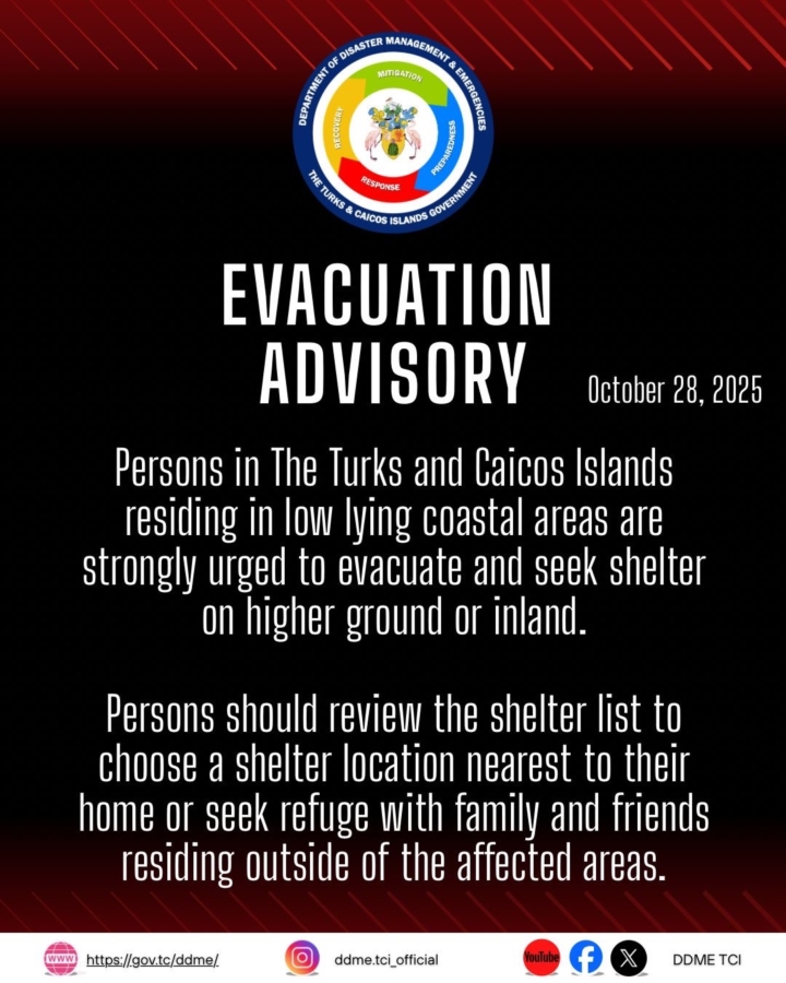
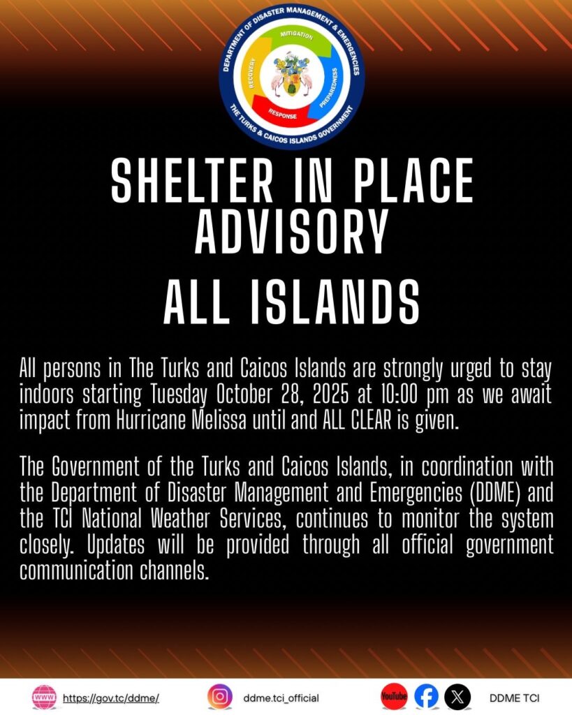
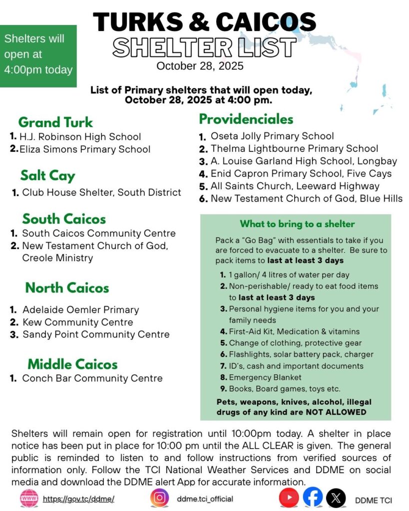
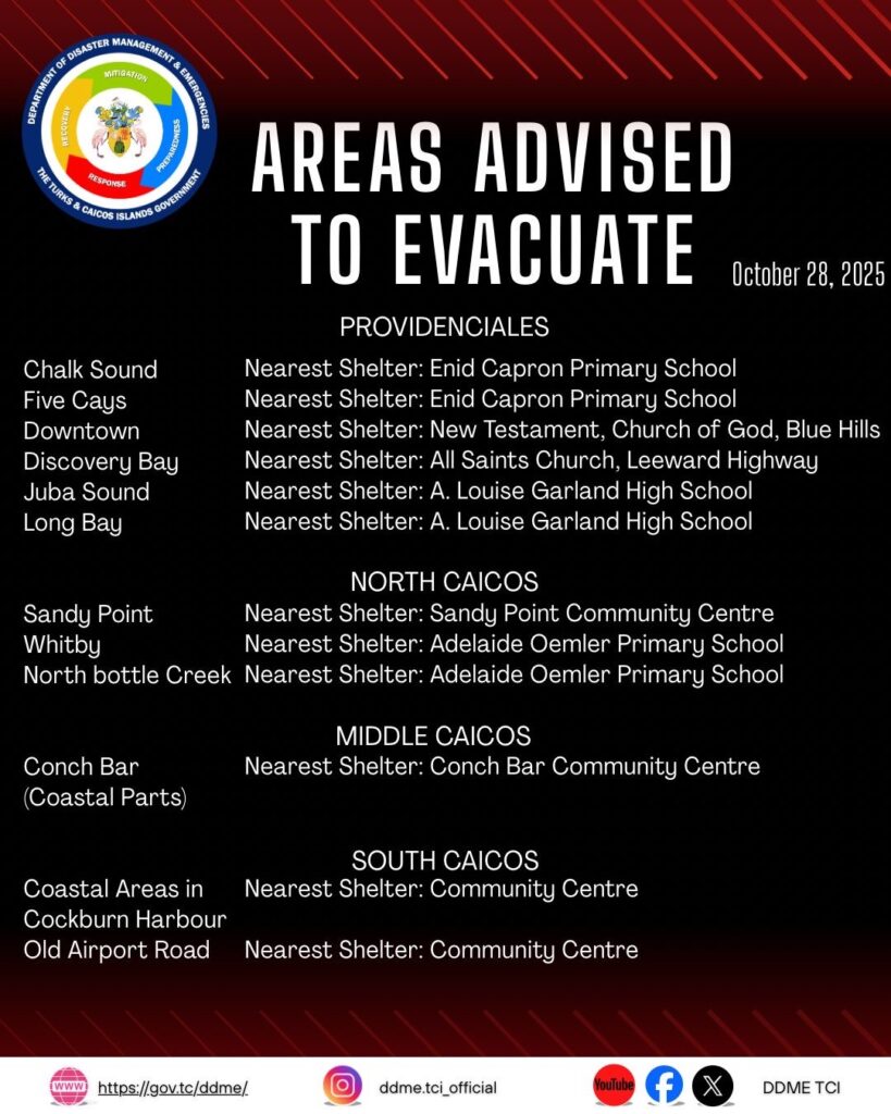
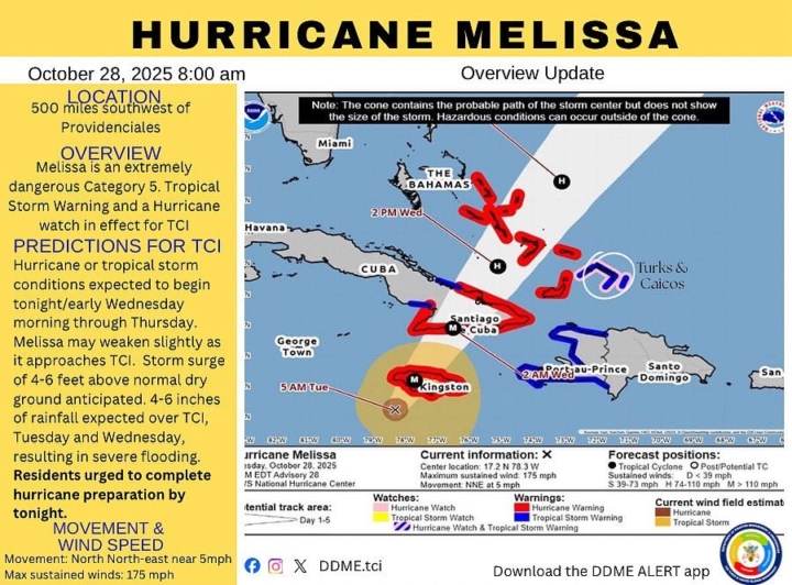
Tropical Storm Warning and Hurricane Watch in effect for TCI
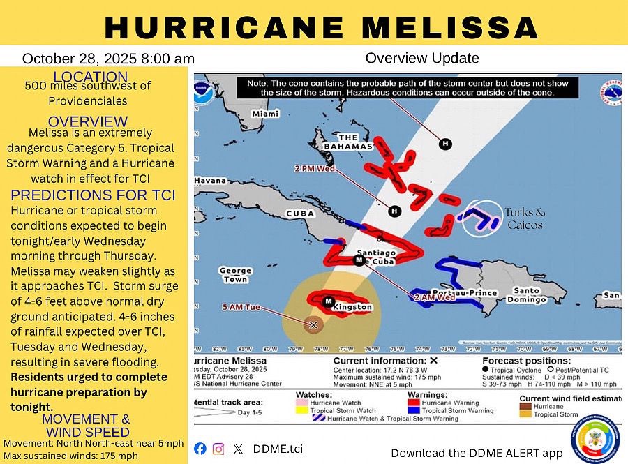
A Tropical Storm Warning means that Tropical Storm conditions are expected in the mentioned islands within 36 hours
A Hurricane Watch means that Hurricane conditions could be experienced within the mentioned islands within 48 hours.
Residents should rush to complete Hurricane preparations by tonight. Tropical Storm or Hurricane conditions expected tonight/early Wednesday morning through Thursday.
At 5 AM EDT, the center of Hurricane Melissa was located near latitude 17.2 degrees north and longitude 78.3 degrees west 500 miles Southwest of Providenciales, Turks and Caicos Islands.
Hurricane Melissa is moving toward the North-Northeast near 5 miles per hour. A turn toward the northeast with an increase in forward speed is expected later today, followed by a faster northeastward motion on Wednesday and Thursday.
Maximum sustained winds are near 175 miles per hour with higher gusts. Melissa is a Category 5 hurricane on the Saffir-Simpson Hurricane Wind Scale. Some fluctuations in intensity are likely before Melissa makes landfall on Jamaica later today. However, Melissa is expected to reach Jamaica and southeastern Cuba as an extremely dangerous major hurricane and it will still be at hurricane strength when it moves across the Southeast Bahamas.
Hurricane-force winds extend outward up to 30 miles from the center, and tropical-storm-force winds extend outward up to 195 miles.
Storm surge of 4 to 6 feet above normally dry ground is possible in the Southeast Bahamas and the Turks and Caicos Islands on Wednesday.
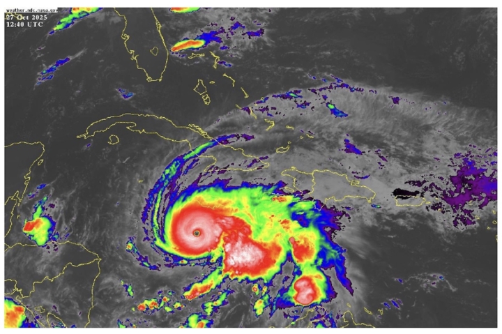
Tropical Weather Advisory #2Issued by the Turks and Caicos Islands National Weather Service
0900 AM EDT Monday 27 October 2025
…HURRICANE WATCH IS IN EFFECT FOR THE TURKS AND CAICOS ISLANDS…
…NOAA AND AIR FORCE RESERVE HURRICANE HUNTERS INVESTIGATIONS CATEGORY 5 MELISSA…
A Hurricane Watch means that hurricane conditions are possible in the Turks and Caicos Islands within the next 48 hours.
Residents in the Turks and Caicos Islands should prepare for the possibility of Hurricane and/or Tropical Storm conditions beginning late Tuesday or early Wednesday morning.
Hurricane conditions, life-threatening storm surge, and heavy rainfall are possible on Wednesday. Residents should follow the advice of local officials and be sure to have preparations complete by Tuesday night.
Total rainfall of 2 to 4 inches is expected across the westernmost islands and 1 to 2 inches across the easternmost islands Tuesday into Wednesday. Heavy rains can produce localized flooding of roads, properties, and communities.
Swells generated by Melissa is expected to produce high seas, dangerous surf and rip currents along the southern and western coastlines.
NEXT UPDATE AT 6PM EDT
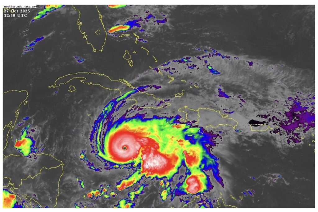
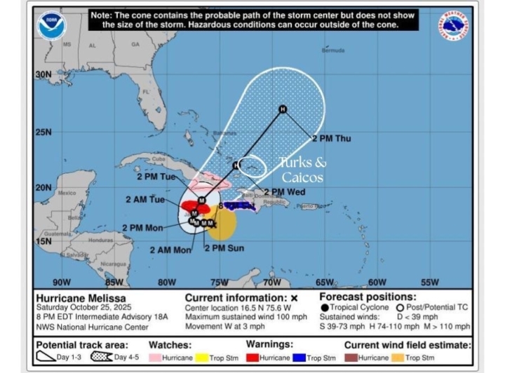
Department of Education Issues School Closure and Hurricane Preparedness Advisory
The Department of Education advises the public that all schools across the Turks and Caicos Islands, including the Turks and Caicos Islands Community College, will close from Monday, 27 October 2025 until further notice in preparation for the possible impact of Hurricane Melissa, which is expected to bring heavy rainfall and possible flooding as early as Tuesday evening, 28 October 2025.
This proactive closure will allow schools designated as emergency shelters to be fully prepared and secured ahead of the expected weather impact.
All principals and staff of public schools must report to their respective schools on Monday, 27 October 2025 to assist with:
- Securing school property and resources
- Organising preliminary cleaning efforts with school cleaners in areas to be used as shelters
- Setting up shelter spaces safely in collaboration with the Department of Disaster Management and Emergencies (DDME).
Parents and guardians residing in low-lying, flood-prone areas are strongly encouraged to take necessary steps to secure life and property and to use designated shelters for safety.
A list of designated shelter locations is available through the Department of Disaster Management and Emergencies: www.gov.tc/ddme
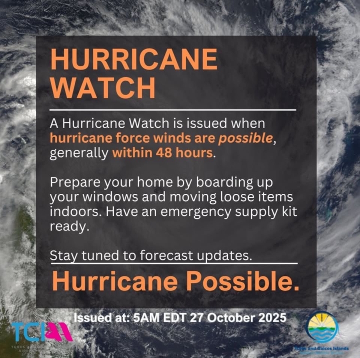
Hurricane Watch is in effect for Turks & Caicos
A Hurricane Watch is now in effect for The Turks and Caicos Islands.
At 5:00 AM EDT on October 27, 2025, the Government of the Bahamas issued a Hurricane Watch for the central and southeastern Bahamas, as well as for the Turks and Caicos Islands. Hurricane conditions are possible within the alert area within the next 48 hours.
Hurricane conditions, life-threatening storm surge, and heavy rainfall are possible on Wednesday. Residents should follow the advice of local officials and be sure to have preparations complete by Tuesday night.
Read full CAP Alert:
English: https://cap-sources.s3.amazonaws.com/tc-gov-en/2025-10-27-10-42-49.xml
Spanish: https://cap-sources.s3.amazonaws.com/tc-gov-es/2025-10-27-10-51-42.xml
Haitian Creole: https://cap-sources.s3.amazonaws.com/tc-gov-ht/2025-10-27-10-46-58.xml
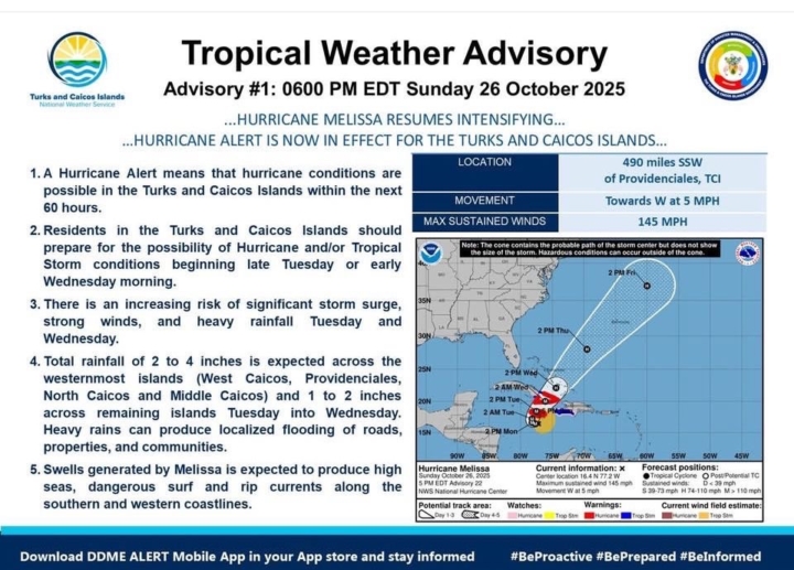
Hurricane Alert is now in effect for the Turks & Caicos
TROPICAL WEATHER ADVISORY #1: 0600 PM EDT SUNDAY, 26 OCTOBER 2025
ISSUED BY THE TURKS AND CAICOS ISLANDS NATIONAL WEATHER SERVICE
…HURRICANE MELISSA RESUMES INTENSIFYING…
…HURRICANE ALERT IS NOW IN EFFECT FOR THE TURKS AND CAICOS ISLANDS…
A Hurricane Alert means that hurricane conditions are possible in the Turks and Caicos Islands within the next 60 hours.
Residents in the Turks and Caicos Islands should prepare for the possibility of Hurricane and/or Tropical Storm conditions beginning late Tuesday or early Wednesday morning.
There is an increasing risk of significant storm surge, strong winds, and heavy rainfall Tuesday and Wednesday.
Total rainfall of 2 to 4 inches is expected across the westernmost islands (West Caicos, Providenciales, North Caicos and Middle Caicos) and 1 to 2 inches across remaining islands Tuesday into Wednesday. Heavy rains can produce localized flooding of roads, properties, and communities.
Swells generated by Melissa is expected to produce high seas, dangerous surf and rip currents along the southern and western coastlines.
NEXT UPDATE AT 0900 AM EDT
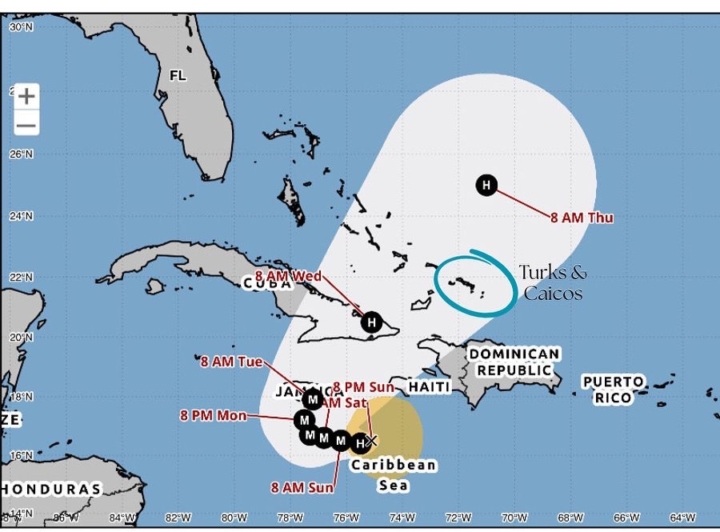
Hurricane Melissa is now a Category 2 hurricane
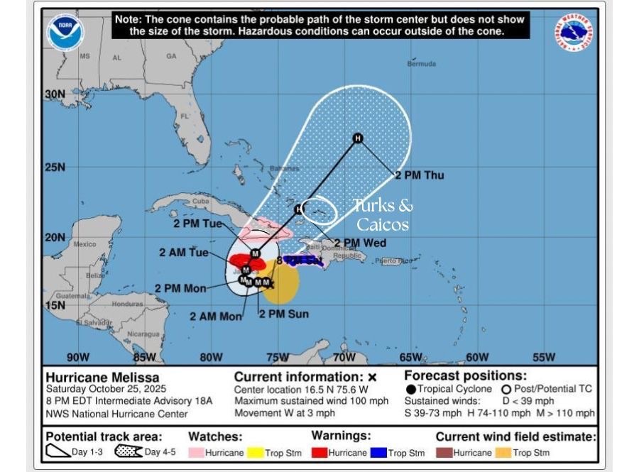
As of 8:00 pm EDT, the center of Category 2 Hurricane Melissa is located about 425 miles south-southwest from Providenciales. Melissa is moving toward the west near 3 mph. A slow westward motion is expected tonight through the end of the weekend. A turn to the north and northeast is forecast on Monday and Tuesday.
Maximum sustained winds have increased to near 100 mph with higher gusts. Rapid intensification is forecast to continue over the next day or so, and Melissa is forecast to become a major hurricane tomorrow and is expected to still be a major hurricane when making landfall in Jamaica early next week.
The Turks and Caicos Islands could begin experiencing tropical storm or hurricane conditions midweek. Residents are urged to review and activate your hurricane action plan, Check and replenish essential supplies (food, water, first‐aid kit, medications, batteries). Secure outdoor objects (furniture, debris), trim tree branches, and consider sandbags or other flood‐mitigation steps Visitors: stay in contact with your hotel/lodging provider and follow any instructions from them.
Monitor updates from The Department of Disaster Management & Emergencies (DDME) and the Turks & Caicos National Weather Service for official information.
TROPICAL WEATHER ADVISORY #1: 0600 PM EDT SUNDAY, 26 OCTOBER 2025
OCTOBER 2025.
…MELISSA NEAR HURRICANE STRENGTH AND FORECAST TO RAPIDLY INTENSIFY THIS WEEKEND…
Visitors and residents are urged to prepare for possible tropical storm or hurricane impact to The Turks and Caicos Islands, mid to late next week.
View the updated report on Tropical Storm Melissa below.
AT 11 AM EDT, THE CENTER OF TROPICAL STORM MELISSA WAS LOCATED NEAR LATITUDE 16.5° NORTH AND LONGITUDE 75.1° WEST.
MELISSA IS MOVING TOWARD THE WEST-NORTHWEST NEAR 1 MPH. A SLOW WEST-NORTHWESTWARD OR WESTWARD MOTION IS EXPECTED TODAY THROUGH SUNDAY NIGHT. A TURN TO THE NORTH AND NORTHEAST IS FORECAST ON MONDAY AND TUESDAY. ON THE FORECAST TRACK, THE CENTER OF MELISSA IS EXPECTED TO MOVE NEAR OR OVER JAMAICA DURING THE WEEKEND AND EARLY NEXT WEEK, AND IT COULD BE NEAR OR OVER EASTERN CUBA BY THE MIDDLE OF NEXT WEEK.

BAHAMAS Government defends decision to use dormant accounts
The Bahamas government is defending its decision to table legislation aimed at transferring funds from dormant accounts to the Disaster Emergency Fund saying that conservative estimates suggest that over 40 per cent of the country’s national debt exists because of climate change.
Prime Minister Phillip Davis told legislators that what’s needed today, more than ever, are innovative, strategic, and sustainable solutions taking on the most pressing climate-related challenges to create opportunities for a more resilient and prosperous future.
“And that is why we are here today. One of the things we have learned is that disaster preparation, and the funding and infrastructure that supports it, must be proactive. It must be sustained, and it must also be robust enough to account for the threats we face.”
Davis said that the resolution currently before the Parliament seeks to ensure that when disasters strike, the government has the financial capacity to respond swiftly, effectively, and equitably.
“In decades past, disaster management in The Bahamas was, unfortunately, reactive, focused mainly on disaster emergency response in the aftermath of a storm,” he said, noting that the passage of Hurricane Dorian on September 1, 2019 “laid bare how woefully unprepared we were for this era of more frequent and more intense storms.
“We cannot allow the flawed response and recovery mechanisms that were exposed by Dorian to be repeated. This is why, in recent years, this administration has transformed our approach from managing disaster responses to managing disaster risk.”
He said the establishment of the Disaster Risk Management Authority (DRMA) represents a fundamental shift in mindset with the focus being on risk reduction, mitigation, preparedness, and recovery.
“We are focused on building resilience before the storm and then rebuilding stronger after it.
The passage of the Disaster Risk Management Act, 2022, was a turning point. It provided the legal foundation for a comprehensive, structured, and accountable disaster management system,” Davis said.
He said this change necessitated a new model for funding disaster-related efforts and that the new strattegy was prepared by the Ministry of Finance in consultation with the DRM Authority and supported by the Inter-American Development Bank (IDB).
“It is a practical, evidence-based, best practice-aligned plan that funds every stage of our disaster risk management cycle. We are funding risk analysis, which allows us to know the extent of the risks we are facing. We are funding risk reduction, so we can take decisive, proactive action to minimise damage before it occurs.”
Davis said the strategy was developed by experts using advanced risk analyses and post-disaster risk assessments to identify our risk profile, quantify potential losses, and enhance our financing capacity, ensuring that our mitigation and response mechanisms are adaptive and resilient.
”The findings from the work of these experts are sobering. The government faces potential losses of up to US$700 million from major hurricane and flood events,” Davis said, adding “that is the scale of damage the government must be prepared to face from a disaster”.
He said the strategy recommends a layered approach such as a blend of investments, insurance, and reserves to diversify risk and reduce fiscal pressure.
Prime Minister Davis said that the resolution beforethe Parliament represents another important step forward toward funding the country’s disaster risk management efforts.
He said under Section 19 of the Disaster Risk Management Act, the Disaster Emergency Fund must be maintained and used to finance response, rehabilitation, recovery, and financial protection instruments.
Prime Minster Davis said the experts have determined that this Fund should hold a minimum of US$17 million to ensure adequate liquidity following a severe natural disaster.
“This resolution authorises the transfer of US$17 million from the dormant account proceeds held by the Treasurer, which are now part of the Consolidated Fund, into the Disaster Emergency Fund.
“These dormant accounts are, essentially, unclaimed resources that can now serve a national purpose. Resources that were sitting idle can now be used to invest in our future and serve as the first line of defence when disaster strikes,” Davis said, noting that currently, regulations and operating procedures are being developed to ensure the efficient and effective management of these funds.
He said the regulations will clearly outline what the funds can be used for, how unused funds can be invested to grow the fund, what will activate their use, and the appropriate steps that must be taken to ensure accountability.
Davis said that these funds ensure that when disaster strikes, the government can mobilise immediate assistance without delays or dependence on external financing.
“By capitalizing this Fund today, we are advancing the goals of our Comprehensive Financial Strategy for Disaster Risk Management. And we are reducing potential losses by 45 per cent over the next decade, which will improve fiscal resilience so that each storm that makes landfall does not drive us deeper into debt.
“We cannot prevent storms from forming. But we can strengthen our nation’s capacity to withstand and recover from them,” Davis said, adding “that is what today is about”.
Source-CMC