A dissipating frontal boundary will move swiftly across the Turks and Caicos Islands today. Widely scattered showers and isolated thunderstorms are occurring along and ahead of the boundary.
WEATHER: Partly cloudy to cloudy with a medium (40 to 50 percent) chance of scattered showers and isolated thunderstorms through tonight. New total rainfall accumulation of up to a half of an inch, with higher amounts possible in thunderstorms.
WINDS: Variable at 10 knots or less, becoming northwesterly at 10 knots or less tonight.
SEAS: Caicos Bank – 3 feet or less; Atlantic – 2 to 4 feet
DAYTIME HIGH TEMPERATURE 90°F 32°C
HEAT INDEX 104°F 40°C
OVERNIGHT LOW TEMPERATURE 79°F 26°C
SUNSET: 06:24 PM
NEXT HIGH TIDE: 04:32 PM (2.6 FT)
NEXT LOW TIDE: 11:08 PM (1.0 FT)
EXTENDED FORECAST: Drier conditions will follow behind the frontal boundary. Over the weekend, high pressure will build across the area, bringing a dry air mass and breezy conditions across the islands.
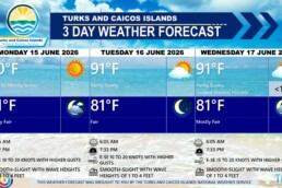
THURSDAY: A low (10 to 20 percent) chance of isolated showers. Partly cloudy, with a high near 88°F (31°C).
THURSDAY NIGHT: Mostly fair, with a low around 79°F (26°C).
WINDS: Northwesterly at 10 knots or less
SEAS: Caicos Bank – 3 feet or less; Atlantic – 3 to 5 feet
SUNRISE: 06:45 AM
SUNSET: 06:23 PM
HIGH TIDE: 04:45 AM (2.0 FT) 05:30 PM (3.0 FT)
LOW TIDE: 10:55 AM (0.3 FT)
FRIDAY: Isolated showers possible in the afternoon. Partly sunny, with a high near 88°F (31°C).
FRIDAY NIGHT: Fair, with a low around 77°F (25°C).
WINDS: Northwest to north at 10 knots or less, falling light and variable at times.
SEAS: Caicos Bank – 3 feet or less; Atlantic – 4 to 6 feet
SUNRISE: 06:45 AM
SUNSET: 06:22 PM
HIGH TIDE: 05:50 AM (2.7 FT) 06:24 PM (2.6 FT)
LOW TIDE: 12:01 AM (0.7 FT) 12:01 PM (1.0 FT)
TROPICAL WEATHER OUTLOOK: See the latest News Item issued by the Bahamas Department of Meteorology on newly formed Tropical Storm Lorenzo, located in the central Tropical Atlantic.
Tropical cyclone formation is not expected during the next 7 days.
FORECASTER: H. HAMILTON