GENERAL SITUATION: A weak high pressure system will continue to support hot and mostly sunny conditions across the Turks and Caicos Islands today.
SPECIAL WARNINGS: The heat index may reach the low 100s today. Heat cramps and heat exhaustion are possible; prolonged exposure could lead to heat stroke. Stay hydrated, take breaks in the shade, and avoid strenuous activity during peak hours.
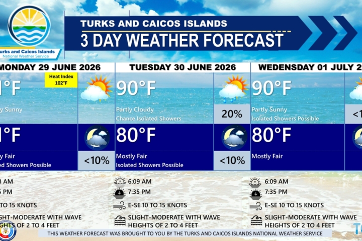
WEATHER: A mix of sun and clouds with isolated showers possible this afternoon. Mostly fair tonight.
WINDS: East to southeast at 10 to 15 knots, falling light and variable at times.
SEAS: 3 feet or less
DAYTIME HIGH TEMPERATURE 90°F 32°C
OVERNIGHT LOW TEMPERATURE 78°F 25°C
HEAT INDEX 103°F 39°C
SUNSET: 07:23 PM
NEXT LOW TIDE: 04:05 PM (2.3 FT)
NEXT HIGH TIDE: 10:20 PM (0.7 FT)
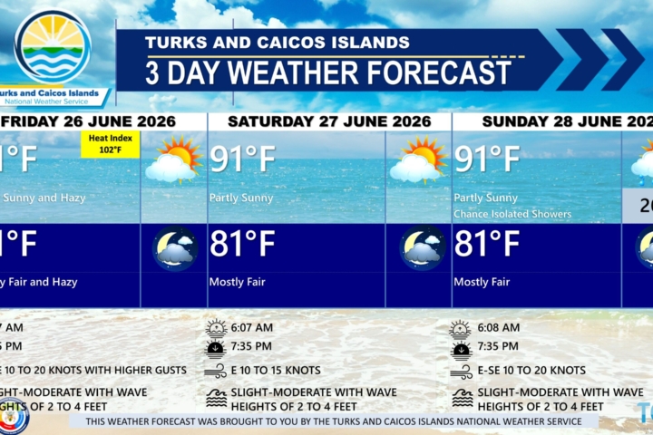
EXTENDED FORECAST: The high pressure will gradually shift eastward through tonight. By Thursday, a new ridge from the Northeast Atlantic will build across the Turks and Caicos Islands, maintaining generally fair weather through the weekend.
THURSDAY: Partly sunny to sunny, with a high around 90°F (32°C).
THURSDAY NIGHT: Mostly fair, with a low around 78°F (25°C).
WINDS: East to southeast at 10 to 15 knots.
SEAS: 3 feet or less
SUNRISE: 06:07 AM
SUNSET: 07:23 PM
HIGH TIDE: 04:35 AM (2.3 FT) 05:12 PM (2.6 FT)
LOW TIDE: 10:55 AM (0.7 FT) 11:32 PM (0.7 FT)
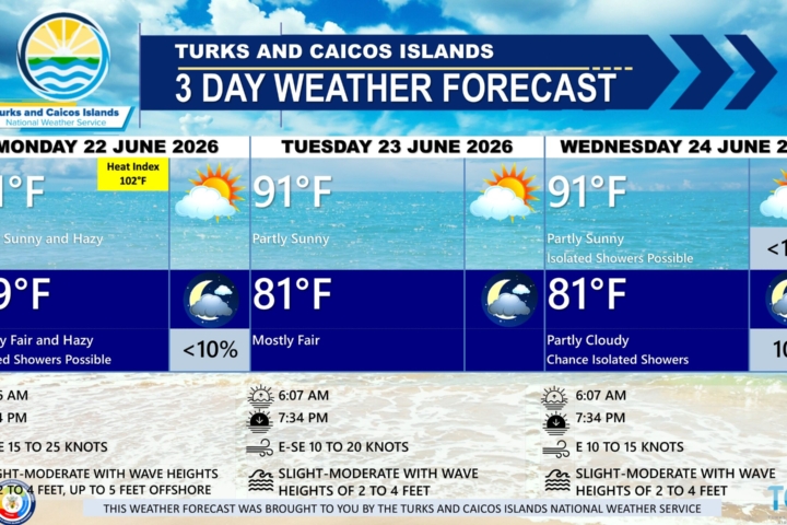
FRIDAY: Isolated showers possible in the early morning. Partly sunny to sunny, with a high around 90°F (32°C).
FRIDAY NIGHT: Mostly fair, with a low around 79°F (26°C).
WINDS: East to southeast at 10 to 15 knots, increasing 15 to 20 knots in the evening.
SEAS: Caicos Bank & Atlantic Nearshore – 3 feet or less; Atlantic Offshore – 2 to 4 feet
SUNRISE: 06:07 AM
SUNSET: 07:24 PM
HIGH TIDE: 05:34 AM (2.3 FT) 06:13 PM (2.6 FT)
LOW TIDE: 11:49 AM (0.7 FT)
TROPICAL WEATHER OUTLOOK: Tropical cyclone formation is not expected during the next seven (7) days. The official 2025 Atlantic Hurricane Season will commence on June 1st.
FORECASTER: H.HAMILTON