GENERAL SITUATION: A stalled frontal boundary extending across the Northwest/Central Bahamas will continue to weaken today as it meanders across the area.
SPECIAL WARNINGS: RESIDENTS ARE ADVISED TO EXERCISE EXTREME CAUTION AS HIGH HEAT INDICES OF 90 TO 105 F ARE EXPECTED TODAY. LIMIT OUTDOOR ACTIVITY AND REMAIN HYDRATED. IN THIS CONDITION, HEAT CRAMPS AND HEAT EXHAUSTION ARE POSSIBLE. CONTINUING ACTIVITY COULD RESULT IN HEAT STROKE.
WEATHER: Mostly sunny and hot today. Mostly fair with isolated showers possible tonight.
WINDS: Easterly at 5 to 10 knots, increasing to 10 to 15 knots tonight
SEAS: 3 feet or less, building up to 2 to 4 feet late tonight.
DAYTIME HIGH TEMPERATURE 88°F HEAT INDEX 97°F
OVERNIGHT LOW TEMPERATURE 75°F
SUNSET: 07:19 PM
NEXT HIGH TIDE: 01:14 PM (2.0 FT)
NEXT LOW TIDE: 07:23 PM (0.7 FT)
EXTENDED FORECAST FOR THE NEXT TWO DAYS: The frontal boundary will weaken and dissipate by early Tuesday. High pressure will build in its wake.
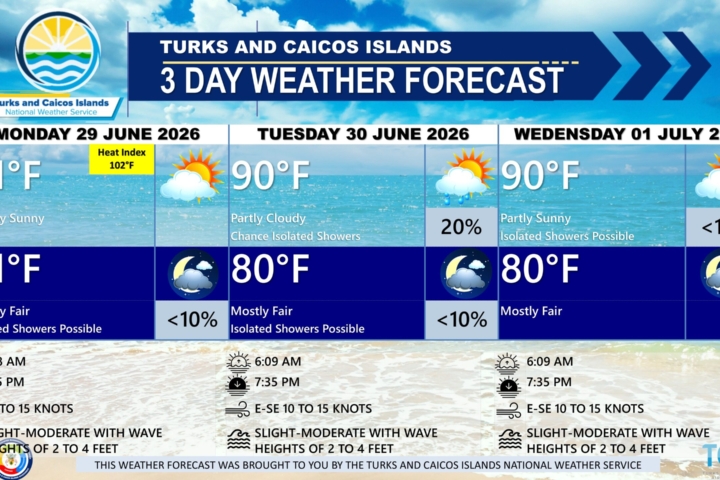
FORECAST FOR TUESDAY
WEATHER: Partly to mostly sunny, with a high near 90. Fair, with a low around 77 at night.
WINDS: Easterly at 10 to 15 knots, increasing to 15 to 20 knots at night.
SEAS: 2 to 4 feet
SUNRISE: 06:10 AM
SUNSET: 07:20 PM
HIGH TIDE: 02:09 AM (2.6 FT)
LOW TIDE: 08:41 AM (1.0 FT)
FORECAST FOR WEDNESDAY
WEATHER: Partly to mostly sunny with isolated showers possible, with a high near 90. Mostly fair, with a low around 77 at night.
WINDS: East to southeast at 10 to 15 knots
SEAS: 2 to 4 feet
SUNRISE: 06:09 AM
SUNSET: 07:20 PM
HIGH TIDE: 03:03 AM (2.6 FT)
LOW TIDE: 09:36 AM (1.2 FT)