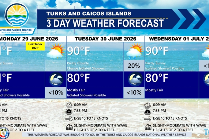
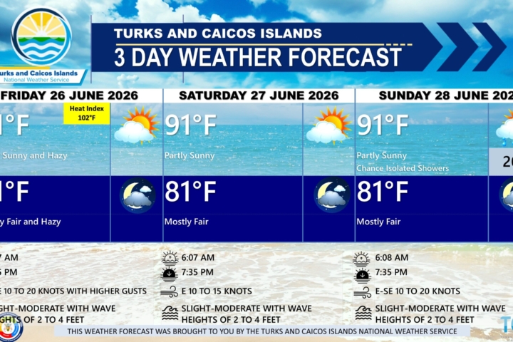
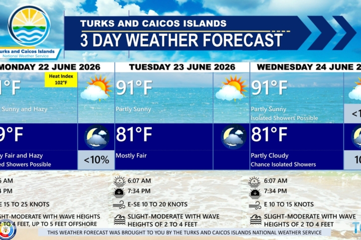
GENERAL SITUATION: High-pressure ridging continues to dominate the weather across the Turks and Caicos Islands.
SPECIAL WARNINGS: THE HEAT INDEX IS HIGH, INCREASING THE RISK OF HEAT-RELATED ILLNESSES SUCH AS HEAT CRAMPS AND HEAT EXHAUSTION. STAY HYDRATED, LIMIT OUTDOOR ACTIVITIES, AND SEEK SHADE OR AIR-CONDITIONED ENVIRONMENTS WHEN POSSIBLE.
WEATHER: Partly to mostly sunny today. Fair and warm tonight.
ADVISORY: A heat advisory is issued when the heat index reaches 105 degrees.
WINDS: Southeast to south at 10 knots or less
SEAS: 3 feet or less
DAYTIME HIGH TEMPERATURE 91°F
OVERNIGHT LOW TEMPERATURE 79°F
SUNSET: 07:21 PM
NEXT HIGH TIDE: 05:12 PM (2.3 FT)
NEXT LOW TIDE: 11:21 PM (1.0 FT)
EXTENDED FORECAST FOR THE NEXT TWO DAYS: The ridge of high pressure will continue to support gentle to moderate winds and dry and mostly stable conditions across the islands over the weekend.
FORECAST FOR SATURDAY
WEATHER: Partly to mostly sunny, with a high near 91. Mostly fair with isolated showers possible, with a low around 81 at night.
WINDS: East to southeast at 10 knots or less, increasing to 10 to 15 knots at night.
SEAS: 2 to 4 feet
SUNRISE: 06:08 AM
SUNSET: 07:22 PM
HIGH TIDE: 05:37 AM (2.3 FT) 06:03 PM (2.3 FT)
LOW TIDE: 11:52 AM (1.0 FT)
FORECAST FOR SUNDAY
WEATHER: Partly to mostly sunny, with a high near 90. Mostly fair with isolated showers possible, with a low around 81 at night.
WINDS: East to southeast at 10 to 15 knots
SEAS: 2 to 4 feet
SUNRISE: 06:08 AM
SUNSET: 07:22 PM
LOW TIDE: 12:17 AM (1.0 FT) 12:30 PM (1.0 FT)
HIGH TIDE: 06:22 AM (2.3 FT) 06:48 PM (2.3 FT)
TROPICAL WEATHER OUTLOOK: Tropical cyclone formation is not expected during the next seven days.
FORECASTER: H. HAMILTON