

Biles and Gilgeous-Alexander Named Best Female and Male Athletes at ESPY Awards
Simone Biles and Shai Gilgeous-Alexander were named Best Female and Male Athletes at the ESPY Awards.
Both superstars walked away with major hardware during the ceremony in Hollywood.
Simone Biles
Gymnastics legend Simone Biles took home two awards.
* Best Athlete, Women's Sports: Honored as the top female athlete.
* Best Championship Performance: Awarded for her historic performance at the Paris Olympics, where she claimed three gold medals and a silver, helping the U.S. team secure a gold medal.
Shai Gilgeous-Alexander
Oklahoma City Thunder superstar and NBA Finals MVP Shai Gilgeous-Alexander also had a massive night.
* Best Athlete, Men's Sports: Named the best male athlete.
* Best NBA Player: Honored for his stellar season in the league.

Florida Man Arrested and Charged with DUI
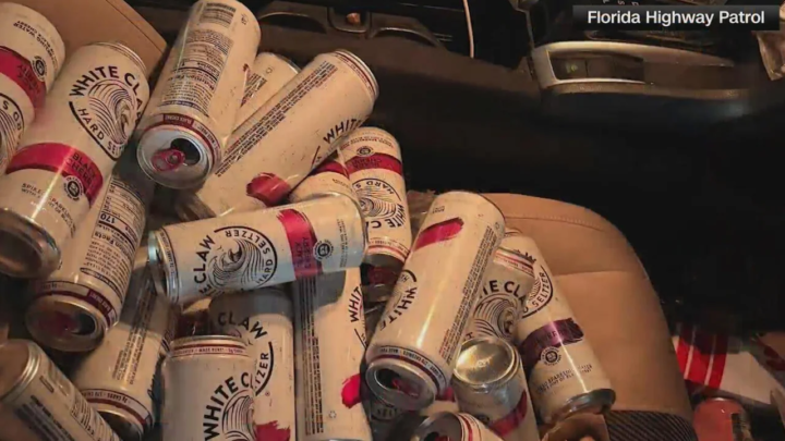
A Florida man was arrested and charged with driving under the influence after troopers say he was found with dozens of open White Claw cans in the passenger seat of his car during a traffic stop.
According to the Florida Highway Patrol, a trooper was on patrol along Interstate 75 near mile marker 280 in Pasco County when he spotted a speeding driver. That vehicle, a Honda Civic, was traveling at more than 90 mph when it passed the trooper, investigators said.
The trooper was able to perform a traffic stop and said that the driver was heavily intoxicated. He was brought to Pasco County Jail with a blood alcohol level of 0.117.
In Florida, the legal Blood Alcohol Content (BAC) limit depends on the type of driver, but for most adults, it is set at 0.08%.
In addition, 34 open White Claw cans were found on the passenger seat of his vehicle, according to Florida Highway Patrol.
The driver, who was identified as Conor William Parady, 34, of San Antonio, was arrested and charged.

U.S. Supreme Court Rules in favor of Trump Administration's Decision to end Temporary Protected Status, or TPS, for Haiti
Hundreds of thousands of Haitians living legally in the United States are now facing an uncertain future after the U.S. Supreme Court ruled in favor of the Trump administration's decision to end Temporary Protected Status, or TPS, for Haiti.
In a 6-3 decision, the nation's highest court cleared the way for the administration to terminate TPS for approximately 350,000 Haitians, removing legal protections that have allowed them to live and work in the United States since the devastating 2010 earthquake.
The ruling overturns lower court decisions that had blocked the administration from ending the program. Writing for the majority, Justice Samuel Alito said federal law clearly limits the courts' authority to review decisions regarding Temporary Protected Status, allowing the administration to move forward with ending the designation.
Without TPS, affected Haitians could become vulnerable to deportation unless they qualify for another form of legal immigration status. Many have lived in the United States for more than a decade, raising families, building careers and contributing to their communities.
The decision comes despite ongoing instability in Haiti. The U.S. State Department continues to advise Americans not to travel to the country because of widespread gang violence, kidnappings and a deteriorating security situation.
The court also rejected claims that the administration's decision was racially discriminatory.
However, the court's three liberal justices strongly disagreed. In a dissenting opinion, Justice Elena Kagan argued there was evidence suggesting race played a role in the decision, pointing to past comments made by President Donald Trump about Haiti and Haitian immigrants.
Immigration advocates have condemned the ruling, warning it could separate families and force thousands of Haitians to return to a country facing a humanitarian and security crisis. They say the decision also creates uncertainty for Temporary Protected Status holders from other countries, as the administration has sought to roll back the program more broadly.
The ruling marks another significant victory for the Trump administration's immigration agenda and is expected to have far-reaching consequences for Haitian families across the United States.
Air Canada Pilot Suffers Medical Emergency Mid-Flight
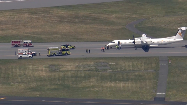
Passengers aboard an Air Canada flight helped crew members manage a pilot who suffered a medical emergency midflight, forcing the aircraft to make an emergency landing in Boston.
Air Canada confirmed Flight AC7664, operated by regional partner PAL Airlines, was traveling from Newark, New Jersey, to Halifax, Nova Scotia, on Wednesday when the captain became incapacitated.
The first officer assumed control of the aircraft and safely diverted the flight to Boston, where the captain was taken to a hospital for treatment.
Passenger Rodney McDonald, who was traveling with his wife and two sons, told ABC News the incident began when the aircraft suddenly swerved.
McDonald said a flight attendant rushed into the cockpit before bringing the captain into the aisle. Believing the pilot was experiencing a seizure, McDonald and several other passengers assisted the crew in keeping him safe while the co-pilot flew the aircraft to Boston.
According to the Centers for Disease Control and Prevention (CDC), people experiencing a seizure should generally not be physically restrained due to the risk of injury. Instead, those nearby should remove dangerous objects, gently turn the person onto their side when possible, and keep the airway clear.
McDonald described the experience as frightening, saying he and several passengers spent about 40 minutes helping manage the situation until the plane landed.
A registered nurse on board also assisted the crew and helped care for the pilot during the emergency, while McDonald praised the flight attendants for remaining calm and professional throughout the ordeal.
The aircraft was carrying 61 passengers.
Emergency responders met the aircraft upon arrival in Boston, and Air Canada said it is arranging alternate travel for those on board. No passengers were injured during the incident.

JCF Seized More than 11,000 Pounds of Cocaine So Far this Year
The Jamaica Constabulary Force (JCF) says it has seized approximately 5,100 kilogrammes (more than 11,000 pounds) of cocaine so far this year, with an estimated street value of about JM$3 billion, over $19,000 US.
According to the JCF, the seizures were made by the Firearms and Narcotics Investigation Division (FNID) through targeted operations that have significantly disrupted transnational organised crime networks.
The force said the quantity of cocaine seized in the first half of 2026 is the highest recorded in the past decade and exceeds the combined total confiscated over the six-year period from 2016 to 2021.
Statistics released by the JCF show that between 2016 and 2025, authorities seized a total of 11,852 kilogrammes, over 26,000 pounds of cocaine.
The 5,100 kilogrammes, over 11,000 pounds of seized cocaine this year alone account for 43 per cent of that decade-long total.
Invest TCI Participated as Platinum Sponsor at ALIS CALA
Invest Turks and Caicos the Islands' Investment Promotion Agency, responsible for enhancing the economy through the attraction, growth and retention of overseas investment; and supporting the growth of local businesses continues to strengthen the country's visibility in key international investment markets through strategic participation in leading regional and global forums focused on hotel development, foreign direct investment, tourism, and inclusive economic growth.
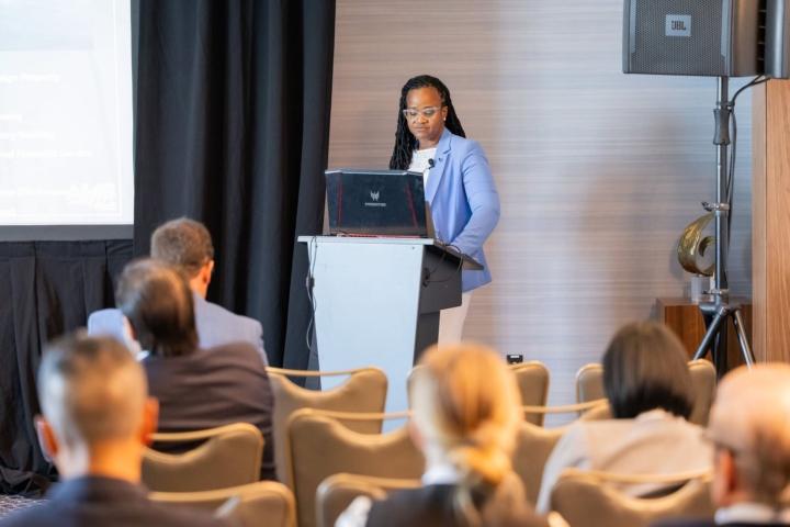
Most recently, Invest TCI participated as a Platinum Sponsor at ALIS CALA, the premier hotel investment conference for the Caribbean and Latin America. The conference brought together hundreds of delegates from more than 35 countries and provided a valuable platform for direct engagement with investors and decision-makers focused on hospitality development across the region.
During the conference, Invest TCI delivered a destination presentation highlighting investment opportunities across the Turks and Caicos Islands, with particular focus on the Family Islands.
The presentation reinforced the Government's broader vision for balanced national development and highlighted emerging prospects beyond Providenciales. It generated strong interest from delegates who viewed the Turks and Caicos Islands as a competitive, high-value Caribbean destination for investment. The session also provided a platform to present the country's value proposition and advance discussions around future projects.
Chief Executive Officer of Invest TCI, Angela Musgrove, said the Agency's participation in international investment forums is an important part of its strategy to keep the Turks and Caicos Islands visible, competitive, and connected to serious investors.
Looking ahead, Invest TCI will participate in the Americas Investment Forum in Santo Domingo, Dominican Republic, in July. The forum will provide another platform for the Agency to engage regional investment stakeholders and strengthen visibility for the Turks and Caicos Islands within the wider investment landscape.
Also in July, the Agency will actively participate in the National Association of Black Hotel Owners, Operators & Developers International African American Hotel Ownership & Investment Summit. Invest TCI's engagement in NABHOOD also supports its commitment to creating pathways for local investors to access international industry knowledge, understand current hotel investment trends, and identify potential partnership opportunities.
Real Estate Bill 2026 Debated in House of Parliament
Parliament of the Turks and Caicos Islands convened Thursday June 25th in the Nations Capital to discuss the Real Estate Bill 2026. Our Danae Dennie has more.
American Businessman In TCIAA Court Case Found Not Guilty
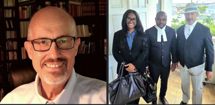
American businessman Robert Koenig has been found not guilty in the Turks and Caicos Islands Airports Authority (TCIAA) corruption trial after the Supreme Court ruled there was no case for him to answer.
Justice Christopher Selochan delivered the ruling on Thursday June 25, 2026, bringing an end to the case against Koenig, who had been charged with conspiracy to defraud in relation to a lighting contract awarded by the TCIAA to LED Industrial Group. Koenig consistently denied the allegation.
At the close of the prosecution’s case, Koenig’s attorneys, Jerome Lynch KC and Mark A. Fulford of F Chambers, submitted that there was no case to answer, arguing that the prosecution had failed to present evidence capable of establishing the essential elements of the offence.
The defence maintained that, even when viewed at its highest, the prosecution’s evidence did not demonstrate that Koenig knowingly entered into a dishonest agreement to defraud the Airports Authority. They further argued there was no evidence linking him to the Authority’s procurement process or showing that a reference letter relied upon by the prosecution influenced the award of the contract.
According to the defence, the prosecution’s case relied on inference, association, and suspicion rather than evidence capable of supporting a criminal conviction.
Justice Selochan accepted the submission and directed a verdict of not guilty.
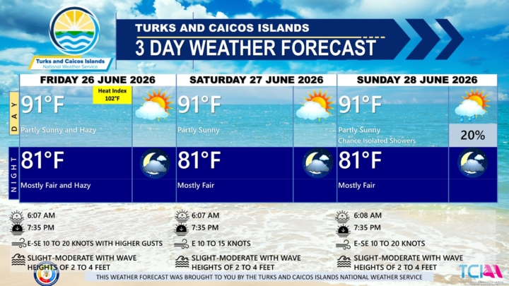
3 DAY PUBLIC WEATHER FORECAST FROM FRIDAY JUNE 26TH 2026
GENERAL SITUATION: High pressure ridging is maintaining generally stable conditions across the Turks and Caicos Islands today, while a Saharan dust plume is bringing hazy skies and reduced visibility.
SPECIAL WARNINGS/ADVISORIES: A Dust Advisory is now in effect for the Turks & Caicos Islands as Saharan Dust moves through the island chain today. Moderate Saharan dust concentrations will reduce visibility at times and possibly impact air quality. Residents, especially those with respiratory conditions, should take the necessary precautions to safeguard their health.
UV Index: The public is advised to wear protective clothing and sunscreen, and seek shaded areas while outside during peak sunshine hours (11am – 4pm), as UV indices are expected to be in the very high to extreme range.
AREA: ALL AREAS
WEATHER: Mostly fair and hazy today.
WINDS: East to southeast at 10 to 20 knots with higher gusts
SEAS: Slight to moderate with wave heights of 2 to 4 feet
DAYTIME HIGH TEMPERATURE 91°F 33°C
HEAT INDEX 102°F 39°C
OVERNIGHT LOW TEMPERATURE 81°F 26°C
SUNSET: 07:35 PM
NEXT LOW TIDE: 12:44 PM (0.7 FT)
NEXT HIGH TIDE: 07:15 PM (3.0 FT)
EXTENDED FORECAST: Generally stable conditions will persist into the start of the weekend, before gradually giving way as high pressure shifts eastward.
SATURDAY: Partly sunny, with a high near 91°F (33°C).
SATURDAY NIGHT: Mostly fair, with a low around 81°F (27°C)
WINDS: Easterly at 10 to 15 knots
SEAS: Slight to moderate with wave heights of 2 to 4 feet
SUNRISE: 06:07 AM
SUNSET: 07:35 PM
LOW TIDE: 01:49 AM (1.0 FT) 01:28 PM (0.7 FT)
HIGH TIDE: 07:29 AM (2.3 FT) 07:59 PM (3.0 FT)
SUNDAY: A low (10 to 20 percent) chance of isolated showers in the morning. Partly sunny, with a high near 91°F (33°C).
SUNDAY NIGHT: Mostly fair, with a low around 81°F (27°C)
WINDS: East to southeast at 10 to 20 knots
SEAS: Slight to moderate with wave heights of 2 to 4 feet
SUNRISE: 06:08 AM
SUNSET: 07:35 PM
LOW TIDE: 02:29 AM (1.0 FT) 02:09 PM (0.7 FT)
HIGH TIDE: 08:09 AM (2.3 FT) 08:41 PM (3.0 FT)
TROPICAL WEATHER OUTLOOK: Tropical cyclone activity is not expected during the next 7 days.
Forecaster: Dr. H. Hamilton
Orange County University Confers Honorary Doctorate on Courtney S. Robinson
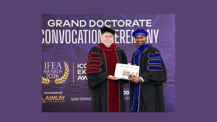
Orange County University has awarded an honorary Doctorate of Philosophy in Strategic Communications and Leadership to Dr. Courtney S. Robinson in recognition of his distinguished career in communications, cultural development, tourism, and public service.
The honorary degree was conferred during the university’s June 6 convocation ceremony, where civic leaders, alumni, family members, and guests gathered to celebrate Robinson’s decades of contributions to institutional leadership, creative industries, and national development.
University officials praised Robinson for his work in government communications, destination marketing, media production, and mentorship, noting that his leadership has strengthened public institutions through the implementation of editorial governance, crisis communications protocols, and integrated communications systems. His efforts have also promoted authentic and sustainable approaches to tourism and cultural preservation while creating opportunities for local talent.
Robinson’s career has included service with the Turks and Caicos Islands Government Information Service, the Turks and Caicos Tourist Board, Experience Turks and Caicos, and a number of international consulting roles.
He is also the founder of Islander Fashions and the TCI Top Model Contest, initiatives that helped transform fashion, modelling, and the creative arts into viable professional careers through training, international exposure, and industry partnerships.
Accepting the honorary doctorate, Robinson described the award as both a personal honour and a renewed commitment to public service.
RTC spoke with Dr. Robinson on the honor.
In recognising Dr. Robinson, Orange County University said the award reflects its commitment to honouring leaders whose work combines creativity, ethical leadership, and public service while making lasting contributions to their communities.
Congratulations Dr. Robinson! 🥳