GENERAL SITUATION: Scattered moderate convection is occurring near a frontal boundary just east of the Turks and Caicos Islands. Hot weather conditions will persist today with the odd shower or two.
SPECIAL WARNINGS: A HEAT ADVISORY IS IN EFFECT FROM 10 AM TO 4 PM FOR THE TURKS AND CAICOS ISLANDS. THE PUBLIC IS URGED TO STAY COOL, AND HYDRATED, AND AVOID PROLONGED EXPOSURE DURING PEAK SUNSHINE HOURS.
WEATHER: Partly sunny with isolated showers or thunderstorms possible in the afternoon. Partly cloudy with isolated showers or thunderstorms possible this evening.
WINDS: East to southeast at 5 to 15 knots
SEAS: 4 to 6 feet over the ocean
DAYTIME HIGH TEMPERATURE 91°F 33°C HEAT INDEX 108°F 42°C
OVERNIGHT LOW TEMPERATURE 81°F 27°C
SUNSET: 06:24 PM
NEXT LOW TIDE: 02:08 PM (0.7FT)
NEXT HIGH TIDE: 07:54 PM (2.6 FT)
EXTENDED FORECAST FOR THE NEXT TWO DAYS: A fairly moist and unstable weather pattern will continue across the islands due to the proximity to mid to low-level troughing.
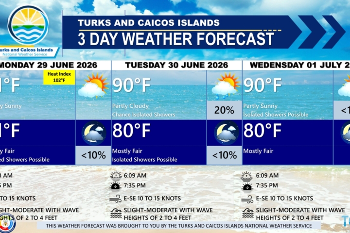
FORECAST FOR TUESDAY
WEATHER: A very slight chance of showers in the morning, then a slight chance of showers or isolated thunderstorms in the afternoon. Partly cloudy, with a high near 91. Chance of rain is 20 percent. Slight chance of showers or isolated thunderstorms at night. Partly cloudy, with a low around 80. Chance of rain is 20 percent. New rainfall total amounts between a tenth to a third of an inch, except higher amounts possible in thunderstorms.
WINDS: East to southeast at 10 to 15 knots
SEAS: 3 to 5 feet over the ocean, subsiding to 2 to 4 feet by the evening.
SUNRISE: 06:45 AM
SUNSET: 06:23 PM
LOW TIDE: 02:03 AM (0.3 FT)
HIGH TIDE: 08:31 AM (3.3 FT)
FORECAST FOR WEDNESDAY
WEATHER: A very slight chance of showers or isolated thunderstorms in the morning, then a chance of showers and thunderstorms in the afternoon. Partly cloudy, with a high near 90. Chance of rain is 30 percent. A very slight chance of showers or isolated thunderstorms at night. Partly cloudy, with a low around 80. Chance of rain is 10 percent. New rainfall total amounts between a tenth to a quarter of an inch, except higher amounts possible in thunderstorms.
WINDS: Southeast to south at 10 to 15 knots, shifting east to southeast in the evening.
SEAS: 2 to 4 feet over the ocean
SUNRISE: 06:45 AM
SUNSET: 06:23 PM
LOW TIDE: 02:51 AM (0.3 FT)
HIGH TIDE: 09:22 AM (3.3 FT)
TROPICAL WEATHER OUTLOOK: The National Hurricane Center is monitoring a well-defined area of low pressure Invest 94L, located several hundred miles west of the Cabo Verde Islands. The system has a medium (50%) formation chance through the next 7 days. A tropical depression could form as the system begins moving west-northwestward and approaches or moves near the Leeward Islands late this week. Residents and visitors should continue to monitor future official updates regarding this system.