

TCI Judiciary Hosts Open Day for Students Across the Islands
Students from across the Turks and Caicos Islands received a firsthand look at the justice system as the TCI Judiciary opened its doors for a special Open Day.
The initiative brought young people inside the courts to learn more about how the judicial system operates, the role of judges and other court officials, and the range of careers available within the legal profession.
We'll turn over to Danae Dennie from Grand Turk...
A similar exercise was conducted in Providenciales with her Honor the Chief Justice Yonette Cummings-Edwards and Her Excellency the Governor Dileeni Daniel-Selvaratnam.
Beyond giving students a closer look at the court system, the Open Day also highlighted the wide range of career opportunities available within the Judiciary.
From judges, magistrates and attorneys to court clerks, administrative professionals and other support roles, students were encouraged to consider how their own skills and interests could lead to a future in the justice system—perhaps inspiring the next generation of legal and judicial professionals in the Turks and Caicos Islands.

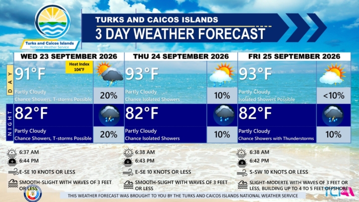
3 DAY PUBLIC WEATHER FORECAST FROM WEDNESDAY SEPTEMBER 23RD 2026
GENERAL SITUATION: A weak pressure gradient is maintaining light to gentle winds and smooth to slight seas across the Turks and Caicos Islands today.
SPECIAL WARNINGS: No public warnings in effect at this time.
ALL AREAS
WEATHER: Partly cloudy with a low (10 to 20 percent) chance of isolated showers with an isolated thunderstorm possible through tonight.
WINDS: East to southeast at 10 knots or less
SEAS: Smooth to slight with wave heights of 3 feet or less
DAYTIME HIGH TEMPERATURE 91°F 33°C
HEAT INDEX 104°F 39°C
OVERNIGHT LOW TEMPERATURE 82°F 28°C
SUNSET: 06:44 PM
NEXT LOW TIDE: 12:24 PM (1.0 FT)
NEXT HIGH TIDE: 06:54 PM (2.6 FT)
EXTENDED FORECAST: Light to gentle winds are expected to persist across the Turks and Caicos Islands through the end of the week. An approaching cold front is expected to near the islands by the weekend before weakening, with prefrontal showers and thunderstorms possible Friday night into the weekend.
THURSDAY: A low (10 percent) chance of isolated showers. Partly cloudy, with a high near 93°F (34°C).
THURSDAY NIGHT: A low (10 percent) chance of isolated showers. Partly cloudy, with a low around 82°F (28°C).
WINDS: East to southeast at 10 knots or less
SEAS: Smooth to slight with wave heights of 3 feet or less
SUNRISE: 06:38 AM
SUNSET: 06:43 PM
LOW TIDE: 01:14 AM (1.0 FT) 01:15 PM (0.7 FT)
HIGH TIDE: 07:09 AM (2.3 FT) 07:35 PM (2.6 FT)
FRIDAY: Isolated showers possible. Partly cloudy, with a high near 93°F (34°C).
FRIDAY NIGHT: A low (10 percent) chance of isolated showers with thunderstorms. Partly cloudy, with a low around 82°F (28°C).
WINDS: South to southwest at 10 knots or less
SEAS: Slight to moderate with wave heights of 3 feet or less, building up to 4 to 5 feet offshore
SUNRISE: 06:38 AM
SUNSET: 06:42 PM
LOW TIDE: 01:51 AM (1.0 FT) 02:04 PM (0.7 FT)
HIGH TIDE: 07:54 AM (2.6 FT) 08:15 PM (2.6 FT)
TROPICAL WEATHER OUTLOOK:
1. Far Eastern Tropical Atlantic: An area of low pressure, associated with a tropical wave that just moved off the west coast of Africa, has formed about 600 miles southeast of the Cabo Verde Islands. This system could become a short-lived tropical depression on Thursday or Friday while it moves northwestward to northward. However, strong upper-level winds should end the opportunity for development by the weekend. This system has a low chance of formation in the next 2 days and a medium chance of formation in the next 7 days.
2. Central Subtropical Atlantic (Former Tropical Storm Fay): A low-pressure system, formerly Tropical Storm Fay, is located about 800 miles southwest of the Azores. Significant re-development of this system is unlikely while it moves generally westward over the next couple of days. This system has a low chance of development in the next 7 days.
FORECASTER: H. HAMILTON
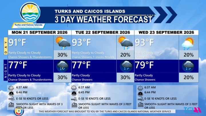
3 DAY PUBLIC WEATHER FORECAST FROM MONDAY SEPTEMBER 21ST 2026
GENERAL SITUATION: Divergent flow aloft combined with tropical moisture is producing clusters of showers and thunderstorms across the Turks and Caicos Islands and its surrounding waters today. A weak pressure gradient is keeping winds light to gentle across the islands.
SPECIAL WARNINGS: There are no public warnings in effect at this time.
ALL AREAS
WEATHER: Partly cloudy to cloudy with a low (10 to 30 percent) chance of showers with an isolated thunderstorm possible through tonight.
WINDS: East to southeast at 10 knots or less
SEAS: Smooth to slight with wave heights of 3 feet or less
DAYTIME HIGH TEMPERATURE 91°F 33°C
OVERNIGHT LOW TEMPERATURE 77°F 25°C
SUNSET: 06:46 PM
NEXT HIGH TIDE: 05:29 PM (2.6 FT)
NEXT LOW TIDE: 11:59 PM (1.3 FT)
EXTENDED FORECAST: The risk of severe weather will ease, however, cloudy and wet conditions are expected to persist through midweek as abundant tropical moisture continues to stream across the Turks and Caicos Islands. Light to gentle winds with smooth to slight seas are expected through early Thursday.
TUESDAY: A low (10 to 20 percent) chance of showers with isolated thunderstorms possible. Partly cloudy to cloudy, with a high near 93°F (34°C).
TUESDAY NIGHT: A low (20 to 30 percent) chance of widely scattered showers. Partly cloudy, with a low around 77°F (25°C).
WINDS: East to southeast at 10 knots or less
SEAS: Smooth to slight with wave heights of 3 feet or less
SUNRISE: 06:37 AM
SUNSET: 06:45 PM
HIGH TIDE: 05:31 AM (2.0 FT) 06:12 PM (2.6 FT)
LOW TIDE: 11:32 AM (1.0 FT) - - - -
WEDNESDAY: A low (10 to 20 percent) chance of widely scattered showers. Partly cloudy, with a high near 93°F (34°C).
WEDNESDAY NIGHT: A low (10 to 20 percent) chance of widely scattered showers. Partly cloudy, with a low around 79°F (26°C).
WINDS: East to southeast at 10 knots or less
SEAS: Smooth to slight with wave heights of 3 feet or less
SUNRISE: 06:37 AM
SUNSET: 06:44 PM
LOW TIDE: 06:21 AM (2.0 FT) 06:54 PM (2.6 FT)
HIGH TIDE: 12:24 PM (1.0 FT) - - - -
TROPICAL WEATHER OUTLOOK:
Active Systems: Tropical Storm Fay is located several hundred miles southwest of the Azores. Fay is moving very slowly toward the south near 5 mph. Maximum sustained winds have decreased to near 50 mph with higher gusts. Continued weakening is forecast, and Fay could degenerate to a post-tropical remnant low in a couple of days.
Tropical cyclone formation is not expected during the next 7 days.
FORECASTER: H. HAMILTON

Koffee's 'Toast' Receives Gold Certification in France
Grammy-winning Jamaican reggae star Koffee has added another international achievement to her growing list of accolades, as her breakthrough single *Toast* has officially been certified gold in France.
The 2018 hit surpassed 15 million streams in the French market, earning the certification from France’s Syndicat national de l’édition phonographique (SNEP). The award was issued Monday, nearly eight years after the song first introduced Koffee to audiences around the world.
The French certification adds to *Toast*’s growing collection of international accolades. The song has already earned platinum status in the United Kingdom after surpassing the equivalent of 600,000 sales and streams, while it has also been certified gold in Canada.
Released in 2018, *Toast* marked Koffee’s international breakthrough and helped launch the then-teenage Spanish Town native onto the global reggae stage. Produced by IzyBeats, with Walshy Fire also credited as a producer, the uplifting track centers on gratitude and appreciation.
*Toast* was later featured on Koffee’s five-track debut EP, *Rapture*, which was released in March 2019. The project went on to achieve historic success, winning Best Reggae Album at the 62nd Grammy Awards in 2020. The victory made Koffee, born Mikayla Simpson, the first woman and, at 19, the youngest artist to win the category.
The song also made its mark on international charts. In the United Kingdom, *Toast* peaked at No. 70 on the Official Singles Chart. In the United States, it reached No. 24 on Billboard’s Rap Airplay chart, No. 37 on Mainstream R&B/Hip-Hop Airplay and No. 47 on R&B/Hip-Hop Airplay.
Its appeal has continued long after its original release. The official music video, which debuted in November 2018, has accumulated more than 289 million views on YouTube.
Meanwhile, *Rapture* debuted at No. 1 on Billboard’s Reggae Albums chart, further cementing Koffee’s position as one of Jamaica’s most prominent young musical talents.
The latest French certification highlights the enduring global appeal of *Toast*, a song that helped introduce Koffee to an international audience and continues to reach new milestones nearly eight years after its release.
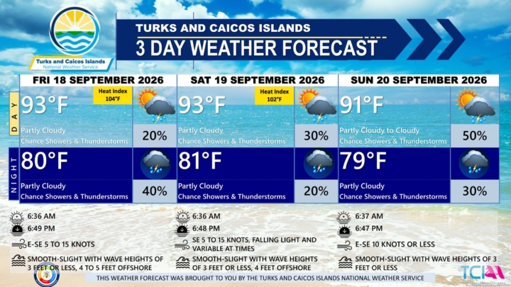
3 DAY PUBLIC WEATHER FORECAST FROM FRIDAY SEPTEMBER 18TH 2026
PUBLIC FORECAST FOR THE TURKS AND CAICOS ISLANDS FOR THE NEXT 3 DAYS FROM FRIDAY 18TH SEPTEMBER 2026
GENERAL SITUATION: A tropical wave and deep layered troughing continue to feed abundant moisture into the Turks and Caicos Islands today, keeping showers and thunderstorms possible at times. Light to gentle winds and smooth seas are expected across all areas.
SPECIAL WARNINGS: There are no public warnings in effect at this time.
Flooding: There is a slight risk of flooding in low-lying and flood-prone areas, with ponding on roads during heavy and prolonged rainfall events.
ALL AREAS
WEATHER: Partly cloudy with a low (10 to 20 percent) chance of showers with isolated thunderstorms this afternoon, then a medium (40 percent) chance of scattered showers and isolated thunderstorms tonight. New rainfall amounts between a tenth and quarter of an inch, except higher amounts possible in thunderstorms.
WINDS: East to southeast at 5 to 15 knots
SEAS: Smooth to slight with wave heights of 3 feet or less, building up to 4 to 5 feet offshore
DAYTIME HIGH TEMPERATURE 93°F 34°C
HEAT INDEX 104°F 39°C
OVERNIGHT LOW TEMPERATURE 80°F 26°C
SUNSET: 06:49 PM
NEXT HIGH TIDE: 02:57 PM (2.6 FT)
NEXT LOW TIDE: 09:34 PM (1.3 FT)
EXTENDED FORECAST: Abundant tropical moisture and upper level forcing will maintain periods of showers and thunderstorms activity across the country over the weekend into early next week.
SATURDAY: A low (20 to 30 percent) chance of showers with isolated thunderstorms. Partly cloudy, with a high near 93°F (34°C).
SATURDAY NIGHT: A low (10 to 20 percent) chance of showers with isolated thunderstorms. Partly cloudy, with a low around 81°F (27°C). New rainfall amounts of about a tenth of an inch.
WINDS: Southeasterly at 5 to 15 knots, falling light and variable at times
SEAS: Smooth to slight with wave heights of 3 feet or less, building up to 4 feet offshore
SUNRISE: 06:36 AM
SUNSET: 06:48 PM
HIGH TIDE: 02:54 AM (2.0 FT) 03:50 PM (2.6 FT)
LOW TIDE: 08:54 AM (1.0 FT) 10:27 PM (1.3 FT)
SUNDAY: A low (20 percent) chance of showers with isolated thunderstorms possible in the morning, then a medium (40 to 50 percent) chance of showers and isolated thunderstorms in the afternoon. Partly cloudy to cloudy, with a high near 91°F (33°C). There is a marginal to slight risk of severe thunderstorms.
SUNDAY NIGHT: A low (20 to 30 percent) chance of showers with isolated thunderstorms. Partly cloudy, with a low around 79°F (26°C). New rainfall amounts between a quarter and half of an inch, except higher amounts possible in thunderstorms.
WINDS: East to southeast at 10 knots or less
SEAS: Smooth to slight with wave heights of 3 feet or less
SUNRISE: 06:37 AM
SUNSET: 06:47 PM
HIGH TIDE: 03:46 AM (2.0 FT) 04:41 PM (2.6 FT)
LOW TIDE 09:45 AM (1.0 FT) 11:16 PM (1.3 FT)
TROPICAL WEATHER OUTLOOK:
1.Eastern Subtropical Atlantic: A trough of low pressure located several hundred miles southwest of the Azores is producing showers and thunderstorms that are showing some signs of organization. This system has a low chance of formation over the next 7 days.
FORECASTER: H. HAMILTON
AUDIO VERSION BELOW:
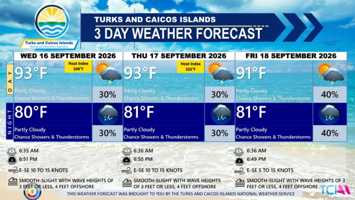
3 DAY PUBLIC WEATHER FORECAST FROM WEDNESDAY SEPTEMBER 16TH 2026
GENERAL SITUATION: An upper-level disturbance over the Turks and Caicos Islands will spark showers and thunderstorms across the islands and surrounding waters through tonight.
ALL AREAS
WEATHER: Partly cloudy with a low (10 to 30 percent) chance of isolated showers with possible isolated thunderstorms through tonight. New rainfall accumulation of about a quarter of an inch.
WINDS: East to southeast at 10 to 15 knots
SEAS: Smooth to slight at wave heights of 3 feet or less, building up to 4 feet offshore
DAYTIME HIGH TEMPERATURE 93°F 34°C
HEAT INDEX 104°F 40°C
OVERNIGHT LOW TEMPERATURE 80°F 26°C
SUNSET: 06:51 PM
NEXT HIGH TIDE: 01:13 PM (2.6 FT)
NEXT LOW TIDE: 07:46 PM (1.0 FT)
EXTENDED FORECAST: The upper-level disturbance will shift northwestward and away from the area on Thursday, with a slight decrease in shower and thunderstorm activity. A tropical wave is expected to move into the area by Thursday night into early Friday, increasing the chance of showers and thunderstorms once again. An elevated risk of severe thunderstorms is possible on Friday.
THURSDAY: A low (30 percent) chance of widely scattered showers with possible isolated thunderstorms. Partly cloudy, with a high near 93°F (34°C).
THURSDAY NIGHT: A low (30 percent) chance of widely scattered showers and isolated thunderstorms. Partly cloudy, with a low around 81°F (27°C). New rainfall accumulation between a half inch and one inch.
WINDS: East to southeast at 10 to 15 knots
SEAS: Smooth to slight at wave heights of 3 feet or less, building up to 4 feet offshore
SUNRISE: 06:36 AM
SUNSET: 06:50 PM
HIGH TIDE: 01:18 AM (2.0 FT) 02:04 PM (2.6 FT)
LOW TIDE: 07:19 AM (1.0 FT) 08:40 PM (1.3 FT)
FRIDAY: A medium (40 percent) chance of scattered showers and isolated thunderstorms. Partly cloudy, with a high near 91°F (33°C). Showers may be heavy and thunderstorms may be strong to severe at times.
FRIDAY NIGHT: A medium (40 percent) chance of scattered showers and isolated thunderstorms. Partly cloudy, with a low around 81°F (27°C). New rainfall accumulation between a quarter of an inch and a half inch.
WINDS: East to southeast at 5 to 15 knots
SEAS: Smooth to slight at wave heights of 3 feet or less, building up to 4 feet offshore
SUNRISE: 06:36 AM
SUNSET: 06:49 PM
HIGH TIDE: 02:05 AM (2.0 FT) 02:57 PM (2.6 FT)
LOW TIDE: 08:06 AM (1.0 FT) 09:34 PM (1.3 FT)
TROPICAL WEATHER OUTLOOK:
1. Central Subtropical Atlantic: A trough of low pressure located several hundred miles east of Bermuda is associated with disorganized showers and thunderstorms. The system has a low chance of formation over the next 7 days.
FORECASTER: H. HAMILTON

Celine Dion Completes Her First Full Concert in Six Years After Battling a Rare Illness
“All By Myself” — the soaring ballad that has been used to measure Celine Dion’s extraordinary voice since 1996 — became the final test of the night.
After more than six years away from a full concert, the Quebec superstar stood before a packed arena outside Paris and sang it again.
It was her first full-length concert since being diagnosed with stiff person syndrome, a rare and progressive neurological disorder that attacks the muscles, including those involved in the throat and voice.
Few people doubted that Dion could still sing. The bigger question was whether she could make it through an entire show — and then have the strength to do it all over again.
Dion answered the crowd with three simple words: “Je vais bien.” — “I’m doing fine.”
At 58 years old, Celine Dion had not performed a full concert since March 8th, 2020. Her diagnosis in 2022 forced her to cancel a world tour and retreat from the stage. For years, fans could only wonder when — or if — she would return, and Saturday night offered them that answer.
At the Plenitude Arena in Nanterre, west of Paris, Dion performed 25 songs over two hours and 15 minutes. It was the opening night of a demanding engagement designed to establish whether she could return to professional touring.
The schedule is relentless: 16 concerts over five weeks, with another 10 already planned for May 2027. In total, she is expected to perform 26 nights in front of tens of thousands of people.
Her last major public performance had lasted only four minutes.
At the 2024 Olympic opening ceremony in Paris, Dion sang one song from the Eiffel Tower. That brief appearance was hailed around the world as a triumphant return.
This time, there was nowhere to hide behind a single song or a single night. She had to perform for more than two hours — and then come back again a few days later.
Stiff person syndrome affects only about one or two people in every million. The condition causes muscles to stiffen and can trigger powerful spasms, sometimes severe enough to break bones. Loud sounds, physical contact and emotional stress can all provoke attacks.
A concert arena is filled with all three.
Dion has previously described singing with the disease as feeling like being strangled.
On Saturday, the emotion nearly overwhelmed her before the music had even begun.
Wearing a Dior gown and a Boucheron necklace, Dion pressed her hands together in prayer. She cried before finishing the first song and later missed her cue during “On ne change pas,” on a line recalling the skinny little girl from Charlemagne, Quebec.
The crowd responded by chanting the familiar riff from “Seven Nation Army,” turning the moment into something between a concert and a communal embrace.
Dion has said she has learned to live with the fragility her illness has brought into her life. Rather than allowing it to end her career, she has made that fragility part of the reason she continues.
Then she kept singing.
Her voice is not exactly the same instrument that helped sell more than 250 million records. Some of its highest notes have become more difficult. Each demanding phrase now carries an added element of risk — and every big note is a decision made in front of 30,000 people.
On Saturday, she made most of those decisions successfully.
Outside the arena, fans arrived wearing sashes emblazoned “Celine Dion 2026,” like pageant contestants, while others wore T-shirts from the LVMH fashion house that happens to share Dion’s first name.
For many, the concert was about far more than music.
Then came the encore.
And the song everyone had been waiting for.
Dion began “All By Myself,” building toward the note that has become one of the defining demonstrations of her vocal power.
It had taken Celine Dion 2,379 days to return to a full concert stage.
Now she has 25 more nights to prove she can stay there.
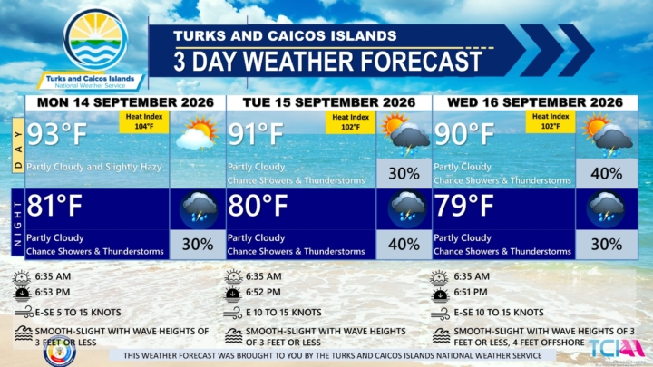
3 DAY PUBLIC WEATHER FORECAST FROM MONDAY SEPTEMBER 14TH 2026
PUBLIC FORECAST FOR THE TURKS AND CAICOS ISLANDS FOR THE NEXT 3 DAYS FROM MONDAY 14TH SEPTEMBER 2026
GENERAL SITUATION: Warm and humid conditions will continue across the Turks and Caicos Islands today, as high pressure ridging remains established and Saharan dust gradually clears through tonight. An upper-level disturbance could spark isolated showers and thunderstorms later tonight.
SPECIAL WARNINGS: A Dust Advisory remains in effect for the Turks and Caicos Islands through tomorrow morning. Sensitive individuals, including those with respiratory and heart issues, young children and the elderly, should take precautionary measures to safeguard their health.
ALL AREAS
WEATHER: Partly cloudy and slightly hazy today, then partly cloudy with a low (20 to 30 percent) chance of widely scattered showers and isolated thunderstorms overnight.
WINDS: East to southeast at 5 to 15 knots
SEAS: Smooth to slight with wave heights of 3 feet or less
DAYTIME HIGH TEMPERATURE 93°F 34°C
HEAT INDEX 104°F 40°C
OVERNIGHT LOW TEMPERATURE 81°F 27°C
SUNSET: 06:53 PM
NEXT LOW TIDE: 06:01 PM (1.0 FT)
NEXT HIGH TIDE: 11:46 PM (2.3 FT)
EXTENDED FORECAST: A combination of upper-level forcing and abundant moisture will establish a wet and unsettled weather pattern across the Turks and Caicos Islands through the week, with periods of showers and thunderstorms expected.
TUESDAY: A low (20 to 30 percent) chance of widely scattered showers and isolated thunderstorms. Partly cloudy, with a high near 91°F (33°C).
TUESDAY NIGHT: A medium (40 percent) chance of scattered showers and isolated thunderstorms. Partly cloudy, with a low around 80°F (26°C).
WINDS: Easterly at 10 to 15 knots
SEAS: Smooth to slight with wave heights of 3 feet or less
SUNRISE: 06:35 AM
SUNSET: 06:52 PM
LOW TIDE: 05:52 AM (0.7 FT) 06:53 PM (1.0 FT)
HIGH TIDE: 12:24 PM (3.0 FT)
WEDNESDAY: A medium (30 to 40 percent) chance of widely scattered showers and isolated thunderstorms. Partly cloudy, with a low around 90°F (32°C).
WEDNESDAY NIGHT: A low (30 percent) chance of widely scattered showers and isolated thunderstorms. Partly cloudy, with a low around 79°F (26°C).
WINDS: East to southeast at 10 to 15 knots
SEAS: Smooth to slight with wave heights of 3 feet or less, building up to 4 feet offshore
SUNRISE: 06:35 AM
SUNSET: 06:51 PM
HIGH TIDE: 12:32 AM (2.0 FT) 01:13 PM (2.6 FT)
LOW TIDE: 06:35 AM (0.7 FT) 07:46 PM (1.0 FT)
TROPICAL WEATHER OUTLOOK:
1. A trough of low pressure located a little more than 1000 miles east-southeast of Bermuda continues to produce disorganized showers and thunderstorms. As the system moves west northwestward across the central part of the Subtropical Atlantic, it is forecast to enter a more conducive environment for gradual development by the middle to latter portion of this week. This system has a low chance of formation over the next 7 days.
FORECASTER: H. HAMILTON

25 Years - Remembering the 9/11 Attacks
Twenty-five years after the Sept. 11, 2001, terrorist attacks, the tragedy remains one of the most significant historical events in the lives of many Americans.
An Ipsos poll found that about half of U.S. adults identified the 9/11 attacks when asked, without being given a list of choices, to name the most important historical events of their lifetimes.
The attacks ranked ahead of several major events that followed, including the COVID-19 pandemic and the elections of Presidents Barack Obama and Donald Trump.
The findings illustrate the lasting impact of Sept. 11, even as a growing share of the U.S. population is too young to remember the attacks or was not yet born when they occurred.
Among Americans who experienced the events of that day, an overwhelming majority say they remember where they were when they first learned about the attacks. About two-thirds of Americans also say Sept. 11 affected the country “a great deal.”
Despite the lasting significance of the tragedy, relatively few Americans say they plan to personally commemorate its 25th anniversary. According to the Ipsos poll, only about 1 in 10 adults plans to mark the anniversary in some way.
For younger Americans, Sept. 11 is an event learned about through history lessons rather than personal experience. A Pew Research Center poll conducted in August found that about 6 in 10 adults born after the attacks first learned about 9/11 in school or through class assignments.
A quarter-century later, the polling suggests Sept. 11 continues to occupy a unique place in the nation’s collective memory, bridging generations that witnessed the attacks firsthand and those who have come to understand their significance through history.
The September 11 attacks, often called 9/11, were a set of four coordinated suicide attacks by the terrorist group al-Qaeda against the United States.
Nineteen al-Qaeda terrorists hijacked four commercial airplanes. Two planes hit the Twin Towers in New York City, causing both to collapse. A third plane crashed into the Pentagon near Washington, D.C. Passengers and crew fought back on the fourth plane, which crashed in a Pennsylvania field.
The tragic events resulted in 2,977 fatalities.... making it the deadliest terrorist act in world history.
World Trade Center
2,753 deaths (including 343 firefighters, 23 NYPD, and 37 Port Authority officers)
The Pentagon
189 deaths (64 on Flight 77, 125 civilian/military personnel)
Flight 93 (Pennsylvania Field)
44 deaths (all passengers, crew, and hijackers)
Today marks the 25th anniversary of the tragedy, with solemn memorial ceremonies held across the United States and throughout US citizens worldwide.

NFL Plays First Regular Season Game Outside of United States
In NFL news... the second game of the season...
The San Francisco 49ers defeated the Los Angeles Rams 27-7 on Thursday, September 10th.
The matchup served as the NFL's first-ever regular-season game played in Melbourne, Australia, hosted at the packed Melbourne Cricket Ground in front of 100,021 fans.
The Rams initially took a 7-3 lead early in the second quarter following a 5-yard rushing touchdown by Kyren Williams. However, the 49ers answered back and completely dominated the rest of the game, scoring 24 unanswered points.
A major turning point occurred in the third quarter when the 49ers' defense executed a vital goal-line stand, stopping Matthew Stafford on a fourth-down quarterback mere inches from the goal line. San Francisco immediately responded with a staggering 11-play, 99-yard drive to break the game open.
Player highlights of the match include:
Brock Purdy (San Francisco 49ers)
205 passing yards, 3 touchdowns, 1 interception
Matthew Stafford (Los Angeles Rams)
155 passing yards, 0 touchdowns, 1 interception
Top Performers
Deebo Samuel Sr., Demarcus Robinson, and Mike Evans all caught touchdown passes for the 49ers. Kyren Williams led the Rams with 41 rushing yards and their lone touchdown.
Football matches continue on Sunday September 13th beginning at 1pm with 13 games on the lineup.