Bahamian Healthcare Workers Travel to China for Training
Twenty-two healthcare professionals from The Bahamas are preparing to travel to China for a public health and hospital management seminar scheduled for October 22–25, as both countries continue strengthening cooperation in the healthcare sector.
The initiative, organised through a partnership between the Government of The Bahamas and the People’s Republic of China, is aimed at expanding professional development opportunities and improving healthcare services throughout the country.
Minister of Health and Wellness Dr Michael Darville confirmed that the delegation will include representatives from the Ministry of Health and Wellness, the Department of Public Health, and the Public Hospitals Authority.
Darville welcomed the opportunity, noting that discussions between the two governments have resulted in a valuable international learning experience for Bahamian healthcare workers.
He explained that the seminar will allow participants to exchange practical knowledge, examine different approaches to hospital administration and public health, and explore strategies that could help improve healthcare delivery in The Bahamas.
Chinese Ambassador to The Bahamas Yan Jiarong also welcomed the initiative, describing it as another example of the growing relationship and continued collaboration between the two nations.
The upcoming training programme follows several health-related partnerships between The Bahamas and China, including the Brightness Action initiative, which provided free cataract surgeries to more than 200 Bahamians earlier this year.

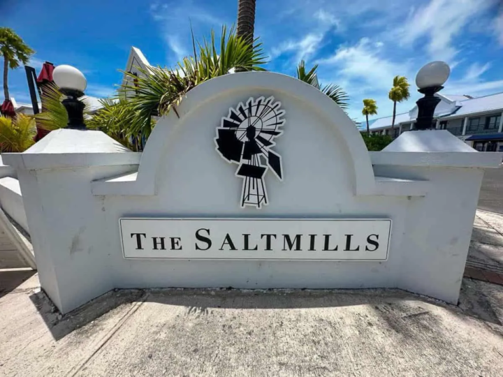
Firefighters Extinguish Blaze at Saltmills Plaza in Grace Bay, Providenciales
At approximately 4:11 p.m. on Sunday, October 18, 2026, the Turks and Caicos Islands Fire and Rescue Service (TCIFRS) received a report of a fire at a commercial establishment within Saltmills Plaza, Grace Bay, Providenciales. The building’s smoke detector activated the alarm, and the monitoring company notified the Fire Service.
Three on-duty firefighters from the Musgrove Fire Station in the South Dock area responded in Tanker 1. An off-duty officer also attended and served as Incident Commander. The crew arrived at approximately 4:28 p.m., 17 minutes after the report was received. The distance between the responding station and Grace Bay contributed to the response time.
On arrival, firefighters met with a building maintenance representative, who reported smoke coming from an air-conditioning vent in the ceiling. Although the plaza includes a two-storey section, the affected establishment is in the single-storey portion.
Firefighters accessed the ceiling space through an access hatch and found a fire involving an electrical cable, surrounding insulation and part of a wooden roof beam. They initially used a fire extinguisher to knock down the flames, then deployed a hose from Tanker 1 to extinguish the remaining burning material. The fire was confined to the area of origin, limiting damage to the wider structure.
Chief Fire Officer Dr. Hezedean Smith commended the crew, stating: “I commend our firefighters for their effective tactical actions in locating and confining the fire to the area of origin. Their professionalism and commitment to protecting lives and property reflect the dedication of our Fire and Rescue Service.”
No injuries were reported among staff or responding firefighters. The incident was concluded without further reported issues.
Man Identified in Fatal Boat Collision, Investigations Continue
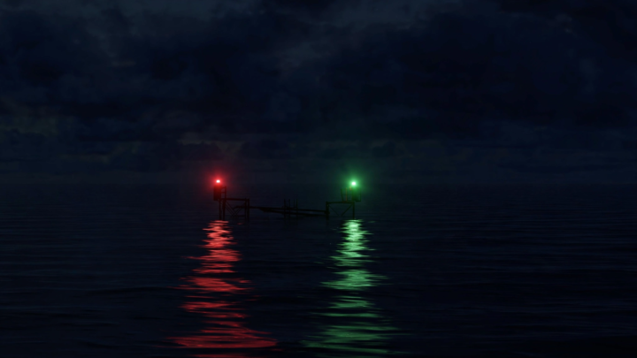
A 43-year-old man has died and four other people have been injured following a serious boat collision in the channel between Dellis Cay and Parrot Cay on Friday night, October 16, 2026.
The deceased has been identified as Paul Harvey, who succumbed to injuries sustained in the collision.
According to the Royal Turks and Caicos Islands Police Force (RTCIPF), emergency services responded to reports of the maritime accident at approximately 8:35 p.m.
Police said six people were aboard a vessel travelling from Belfield Landing to Providenciales when it collided with a Parrot Cay service boat.
Four other individuals were transported to the Cheshire Hall Medical Centre for medical treatment. The extent of their injuries has not been disclosed.
The RTCIPF has extended its deepest condolences to Harvey’s family and loved ones as investigations into the circumstances surrounding the fatal collision continue.
In the wake of the tragedy, police are urging boat captains, vessel operators and members of the boating public to exercise increased caution while navigating local waters, particularly during periods of reduced visibility and heightened boating activity.
Authorities are reminding operators to remain alert, maintain a proper lookout and navigate responsibly to help prevent further tragedies at sea.
Investigations into the collision remain ongoing.
Meanwhile, Fiesta TCI has announced that it will be temporarily closed for the remainder of October following Harvey’s death.
In an official statement, the business described Harvey as a beloved member of its team, saying he was more than an employee and was considered family.
Owner Maria Rolle said the loss has left the team heartbroken and that the temporary closure would allow her and another team member, Mari, time to grieve and support one another.
All bookings scheduled for the remainder of October have been cancelled, with full refunds to be issued to affected clients.
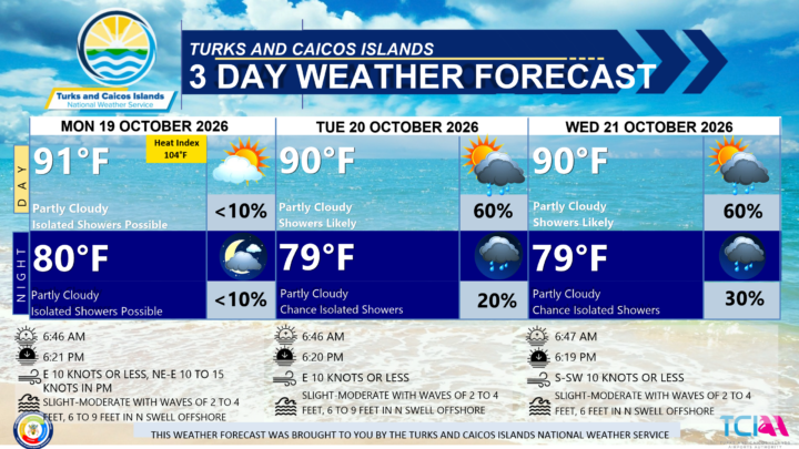
3 DAY PUBLIC WEATHER FORECAST FROM MONDAY OCTOBER 19TH 2026
GENERAL SITUATION: Fair and generally stable conditions are expected across the Turks and Caicos Islands today, however sea conditions will become hazardous as swells move into the area.
SPECIAL WARNINGS: A Small Craft Advisory is in effect for Atlantic waters. Small craft operators should remain near or in port until conditions improve.
Rip currents: There is a slight to moderate risk of rip currents across all Atlantic waters. Beachgoers and swimmers should exercise caution and refrain from entering the water.
WEATHER: Partly cloudy with isolated showers possible through tonight.
WINDS: Easterly at 10 knots or less through this afternoon, becoming northeast to east at 10 to 15 knots during the evening hours
SEAS: Slight to moderate with wave heights of 2 to 4 feet nearshore, building up to 6 to 9 feet offshore in northerly swell by this evening
DAYTIME HIGH TEMPERATURE 91°F 33°C
HEAT INDEX 104°F 40°C
OVERNIGHT LOW TEMPERATURE 80°F 26°C
SUNSET: 06:21 PM
HIGH TIDE: 03:50 PM (2.3 FT)
NEXT LOW TIDE: 10:17 PM (1.3 FT)
EXTENDED FORECAST: Shower and thunderstorm chances will increase across portions of the Turks and Caicos Islands as a frontal boundary stalls nearby, before gradually dissipating late Wednesday into early Thursday. Hazardous sea conditions will persist due to long period swells — mariners and beachgoers should exercise caution.
TUESDAY: Partly cloudy with a low (20 percent) chance of showers in the morning, then a medium (40 to 60 percent) chance of showers with isolated thunderstorms possible in the afternoon. Highs near 90°F (32°C).
TUESDAY NIGHT: Partly cloudy with a low (20 percent) chance of showers with isolated thunderstorm possible. Lows around 79°F (26°C).
WINDS: Easterly at 10 knots or less, falling light and variable at times
SEAS: Smooth to slight with wave heights of 3 feet or less in the Caicos Bank; Slight to moderate with wave heights of 2 to 4 feet nearshore, building up to 6 to 9 feet in northerly swells offshore in Atlantic waters.
SUNRISE: 06:46 AM
SUNSET: 06:20 PM
HIGH TIDE: 03:49 AM (2.0 FT) 04:38 PM (2.3 FT)
LOW TIDE: 09:52 AM (1.0 FT) 11:03 PM (1.0 FT)
WEDNESDAY: Partly to mostly cloudy with a medium (40 to 60 percent) chance of showers with an isolated thunderstorm possible. Highs near 90°F (32°C).
WEDNESDAY NIGHT: Partly cloudy with a low (20 to 30 percent) chance of showers. Lows around 79°F (26°C).
WINDS: South to southwest at 10 knots or less, falling light and variable at times
SEAS: Smooth to slight with wave heights of 3 feet or less in the Caicos Bank; Slight to moderate with wave heights of 2 to 4 feet nearshore, building up to 6 feet in northerly swells offshore in Atlantic waters.
SUNRISE: 06:47 AM
SUNSET: 06:19 PM
HIGH TIDE: 04:49 AM (2.0 FT) 05:26 PM (2.3 FT)
LOW TIDE: 10:54 AM (1.0 FT) 11:46 PM (1.0 FT)
TROPICAL WEATHER OUTLOOK:
1. A storm-force non-tropical low pressure area is located along a frontal boundary a few hundred miles off the southeast coast of the United States. This low is likely to move slowly and erratically over the next couple of days, and it could gradually acquire subtropical characteristics if it remains over the Gulf Stream. This system has a medium chance of tropical formation over the next 7 days.
FORECASTER: H. HAMILTON
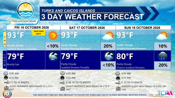
3 DAY PUBLIC WEATHER FORECAST FROM FRIDAY OCTOBER 16TH 2026
GENERAL SITUATION: High pressure maintains relatively warm temperatures and moderate easterly breezes throughout the day.
SPECIAL WARNINGS: There are currently no warnings in effect for the Turks and Caicos Islands.
SPECIAL NOTE: There is a slight risk of rip currents across all Atlantic-exposed waters. Beachgoers and swimmers are advised to exercise caution when entering the water.
ALL AREAS
WEATHER: Mostly sunny with isolated showers possible. Mostly fair tonight.
WINDS: Easterly at 5 to 15 knots
SEAS: Slight to moderate with wave heights of 2 to 4 feet
DAYTIME HIGH TEMPERATURE 93°F 34°C
HEAT INDEX 104°F 40°C
OVERNIGHT LOW TEMPERATURE 79°F 26°C
SUNSET: 06:23 PM
NEXT HIGH TIDE: 01:28 PM (2.6 FT)
NEXT LOW TIDE: 07:54 PM (1.3 FT)
EXTENDED FORECAST: The high pressure will shift eastward today, ahead of strong cold front that will move off the coast of Florida by early Saturday, then stalling near the central Bahamas early next week. Ahead of the front, showers are expected to develop across parts of the Turks and Caicos Islands early next week.
SATURDAY: Partly cloudy with a low (10 to 20 percent) chance of passing showers, especially in the afternoon. Highs near 93°F (34°C).
SATURDAY NIGHT: Partly cloudy with isolated showers possible. Lows around 79°F (26°C).
WINDS: East to southeast at 10 to 15 knots
SEAS: Slight to moderate with wave heights of 2 to 4 feet
SUNRISE: 06:45 AM
SUNSET: 06:22 PM
HIGH TIDE: 01:18 AM (2.0 FT) 02:14 PM (2.6 FT)
LOW TIDE: 07:23 AM (1.0 FT) 08:41 PM (1.3 FT)
SUNDAY: Partly cloudy with a low (10 percent) chance of showers in the afternoon. Highs near 93°F (34°C).
SUNDAY NIGHT: Partly cloudy with a low (10 to 20 percent) chance of isolated showers. Lows around 80°F (26°C).
WINDS: Easterly at 10 to 15 knots
SEAS: Smooth to slight with wave heights of 3 feet or less
SUNRISE: 06:45 AM
SUNSET: 06:21 PM
HIGH TIDE: 02:01 AM (2.0 FT) 03:02 PM (2.3 FT)
LOW TIDE: 08:07 AM (1.0 FT) 09:29 PM (1.3 FT)
TROPICAL WEATHER OUTLOOK:
Tropical cyclone activity is not expected during the next 7 days.
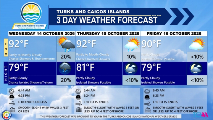
3 DAY PUBLIC WEATHER FORECAST FROM WEDNESDAY OCTOBER 14TH 2026
PUBLIC FORECAST FOR THE TURKS AND CAICOS ISLANDS FOR THE NEXT THREE DAYS FROM WEDNESDAY 14TH OCTOBER 2026
GENERAL SITUATION: Unsettled conditions are expected across the Turks and Caicos Islands today, as an upper-level disturbance interacts with tropical moisture to produce showers and thunderstorms.
SPECIAL WARNINGS: There are no public warnings in effect at this time.
SEVERE THUNDERSTORM RISK: There is a marginal to slight risk for a few isolated strong to severe thunderstorms
across portions of the Turks and Caicos Islands through today. These storms could produce strong gusty winds,
frequent lightning, heavy downpours, and waterspout activity.
ALL AREAS
WEATHER: Partly to mostly cloudy with a low (10 to 20 percent) chance of showers with isolated thunderstorms
WINDS: Easterly at 10 to 15 knots or less
SEAS: Smooth to slight with wave heights of 3 feet or less
DAYTIME HIGH TEMPERATURE 92°F 33°C
HEAT INDEX 104°F 40°C
OVERNIGHT LOW TEMPERATURE 79°F 26°C
SUNSET: 06:25 PM
NEXT LOW TIDE: 06:23 PM (1.0 FT)
NEXT HIGH TIDE: 11:59 PM (2.0 FT)
EXTENDED FORECAST: Conditions are expected to improve by Thursday as moisture shifts out of the region. By early Friday, deep layered ridging will build across the Turks and Caicos Islands, bringing generally stable and breezy conditions through the weekend.
THURSDAY: Partly cloudy with a low (10 percent) chance of isolated showers. Highs near 92°F (33°C).
THURSDAY NIGHT: Mostly fair with isolated showers possible. Lows around 81°F (27°C).
WINDS: Easterly at 10 to 15 knots
SEAS: Smooth to slight with wave heights of 3 feet or less, building up to 4 feet offshore
SUNRISE: 06:44 AM
SUNSET: 06:24 PM
LOW TIDE: 06:02 AM (0.7 FT) 07:08 PM (1.0 FT)
HIGH TIDE: 12:41 PM (2.6 FT)
FRIDAY: Partly cloudy with isolated showers possible. Highs near 92°F (33°C).
FRIDAY NIGHT: Mostly fair with isolated showers possible. Lows around 81°F (27°C).
WINDS: Easterly at 10 to 15 knots
SEAS: Smooth to slight with wave heights of 3 feet or less, building up to 4 feet offshore
SUNRISE: 06:45 AM
SUNSET: 06:23 PM
HIGH TIDE: 12:39 AM (2.0 FT) 01:28 PM (2.6 FT)
LOW TIDE: 06:42 AM (0.7 FT) 07:54 PM (1.3 FT)
TROPICAL WEATHER OUTLOOK:
Tropical cyclone activity is not expected during the next 7 days.
FORECASTER: H HAMILTON
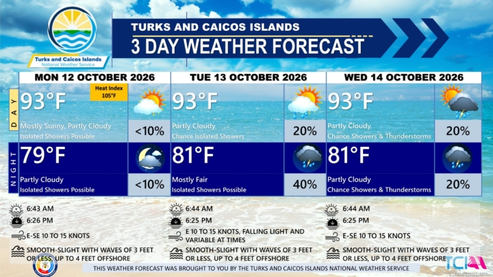
3 DAY PUBLIC WEATHER FORECAST FROM MONDAY OCTOBER 12TH 2026
GENERAL SITUATION: High pressure ridging is maintaining mostly sunny skies across the Turks and Caicos Islands today, with a pop-up shower possible during the afternoon hours.
SPECIAL WARNINGS: No public warnings in effect at this time.
ALL AREAS
WEATHER: Mostly sunny, then partly cloudy with isolated showers possible this afternoon into the evening.
WINDS: East to southeast at 10 to 15 knots
SEAS: Smooth to slight with wave heights of 3 feet or less, building up to 4 feet offshore
DAYTIME HIGH TEMPERATURE 93°F 34°C
HEAT INDEX 105°F 41°C
OVERNIGHT LOW TEMPERATURE 79°F 26°C
SUNSET: 06:26 PM
NEXT LOW TIDE: 04:52 PM (0.7 FT)
NEXT HIGH TIDE: 10:36 PM (2.3 FT)
EXTENDED FORECAST: An upper-level disturbance is expected to move into the region, increasing the chance of showers and thunderstorms across the Turks and Caicos Islands through midweek.
TUESDAY: Partly cloudy with a low (10 to 20 percent) chance of isolated showers in the afternoon. Highs near 93°F (34°C).
TUESDAY NIGHT: Partly to mostly cloudy with a medium (40 percent) chance of scattered showers with an isolated thunderstorm. Lows around 81°F (27°C).
WINDS: Easterly at 10 to 15 knots, falling light and variable at times.
SEAS: Smooth to slight with wave heights of 3 feet or less, building up to 4 feet offshore
SUNRISE: 06:44 AM
SUNSET: 06:25 PM
LOW TIDE: 04:41 AM (0.7 FT) 05:38 PM (1.0 FT)
HIGH TIDE: 11:10 AM (3.0 FT) 11:19 PM (2.3 FT)
WEDNESDAY: Partly cloudy with a low (10 to 20 percent) chance of showers with an isolated thunderstorm possible. Highs near 93°F (34°C).
WEDNESDAY NIGHT: Partly cloudy with a low (10 to 20 percent) chance of showers with an isolated thunderstorm possible. Lows around 81°F (27°C).
WINDS: East to southeast at 10 to 15 knots
SEAS: Smooth to slight with wave heights of 3 feet or less
SUNRISE: 06:44 AM
SUNSET: 06:25 PM
LOW TIDE: 05:22 AM (0.7 FT) 06:23 PM (1.0 FT)
HIGH TIDE: 11:55 AM (3.0 FT) 11:59 PM (2.0 FT)
TROPICAL WEATHER OUTLOOK:
Eastern Tropical Atlantic: An elongated area of low pressure centered a few hundred miles west of the Cabo Verde Islands continues to produce a large but disorganized area of showers and thunderstorms extending from these islands southwestward into the eastern tropical Atlantic. This system has a low chance of formation during the next 7 days.
FORECASTER: H. HAMILTON
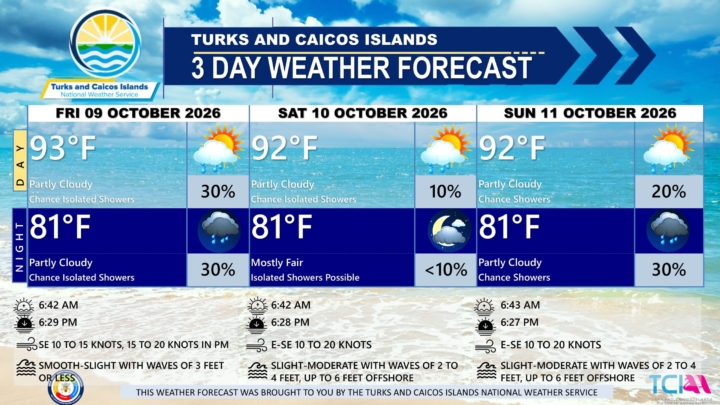
3 DAY PUBLIC WEATHER FORECAST FROM FRIDAY OCTOBER 9TH 2026
GENERAL SITUATION: Streaming moisture associated with a tropical wave near Cuba could spark isolated showers across the Turks and Caicos Islands today.
SPECIAL WARNINGS: There are no public warnings in effect at this time.
ALL AREAS
WEATHER: Partly cloudy with a low (10 to 30 percent) chance of isolated showers through tonight.
WINDS: Southeasterly at 10 to 15 knots, increasing to 15 to 20 knots by the afternoon
SEAS: Smooth to slight with wave heights of 3 feet or less
DAYTIME HIGH TEMPERATURE 93°F 34°C
OVERNIGHT LOW TEMPERATURE 81°F 27°C
SUNSET: 06:29 PM
NEXT LOW TIDE: 02:19 PM (0.7 FT)
NEXT HIGH TIDE: 08:21 PM (2.6 FT)
EXTENDED FORECAST: A drier air mass will move into the area, reducing the chance of showers going into the weekend. High pressure will then build over the weekend, bringing strengthening breezes across the Turks and Caicos Islands.
SATURDAY: Partly cloudy with a low (10 percent) chance of isolated showers. Highs near 92°F (33°C).
SATURDAY NIGHT: Mostly fair with isolated showers possible. Lows around 81°F (27°C).
WINDS: East to southeast at 10 to 20 knots
SEAS: Slight to moderate with wave heights of 2 to 4 feet, building up to 6 feet offshore
SUNRISE: 06:42 AM
SUNSET: 06:28 PM
LOW TIDE: 02:35 AM (0.7 FT) 03:13 PM (0.7 FT)
HIGH TIDE: 08:51 AM (3.0 FT) 09:07 PM (2.6 FT)
SUNDAY: Partly cloudy with a low (10 to 20 percent) chance of isolated showers with possible afternoon thunderstorms. Highs near 92°F (33°C).
SUNDAY NIGHT: Partly cloudy with a low (30 percent) chance of isolated showers. Lows around 81°F (27°C).
WINDS: East to southeast at 10 to 20 knots
SEAS: Slight to moderate with wave heights of 2 to 4 feet, building up to 6 feet offshore
SUNRISE: 06:43 AM
SUNSET: 06:27 PM
LOW TIDE: 03:18 AM (0.7 FT) 04:03 PM (0.7 FT)
HIGH TIDE: 09:39 AM (3.0 FT) 09:52 PM (2.3 FT)
TROPICAL WEATHER OUTLOOK:
Active Systems:
Hurricane Isaias is located over the north-central Gulf of America. Isaias is a category 3 hurricane on the Saffir-Simpson Hurricane Wind Scale. Isaias is expected to approach the U.S. northern Gulf Coast this afternoon and make landfall this evening.
Tropical cyclone formation is not expected during the next 7 days.
FORECASTER: H. HAMILTON
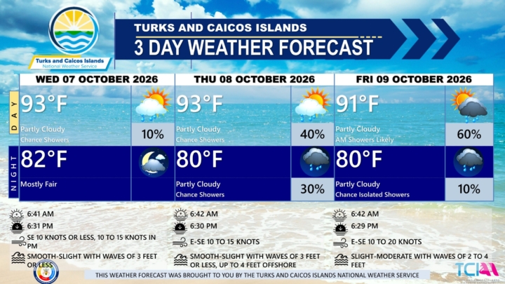
3 DAY PUBLIC WEATHER FORECAST FROM WEDNESDAY OCTOBER 7TH 2026
GENERAL SITUATION: Weak high pressure is maintaining light to gentle winds across the Turks and Caicos Islands today, with a few isolated passing showers possible.
SPECIAL WARNINGS: There are currently no warnings in effect at this time.
ALL AREAS
WEATHER: Partly cloudy with a low (10 percent) chance of isolated showers today. Mostly fair tonight.
WINDS: Southeasterly at 10 knots or less, increasing to 10 to 15 knots tonight.
SEAS: Smooth to slight with wave heights of 3 feet or less
DAYTIME HIGH TEMPERATURE 93°F 34°C
HEAT INDEX 104°F 40°C
OVERNIGHT LOW TEMPERATURE 82°F 28°C
SUNSET: 06:31 PM
NEXT LOW TIDE: 12:20 PM (0.7 FT)
NEXT HIGH TIDE: 06:40 PM (2.6 FT)
EXTENDED FORECAST: A tropical wave is expected to pass south of the Turks and Caicos Islands tomorrow, potentially triggering showers across parts of the islands and surrounding waters. Shower chances will gradually decrease heading into the weekend as high pressure builds across the region, bringing breezy conditions.
THURSDAY: Partly cloudy with a medium (40 percent) chance of showers in the morning, then a low (10 percent) chance of isolated showers in the afternoon. Highs near 93°F (34°C).
THURSDAY NIGHT: Partly cloudy with a low (30 percent) chance of showers. Lows around 80°F (27°C).
WINDS: East to southeast at 10 to 15 knots
SEAS: Smooth to slight with wave heights of 3 feet or less, building up to 4 feet offshore
SUNRISE: 06:42 AM
SUNSET: 06:30 PM
LOW TIDE: 01:06 AM (0.7 FT) 01:22 PM (0.7 FT)
HIGH TIDE: 07:07 AM (2.6 FT) 07:32 PM (2.6 FT)
FRIDAY: Partly cloudy with a medium (60 percent) chance of showers in the morning, then a low (20 percent) chance of isolated showers in the afternoon. Highs near 91°F (33°C).
FRIDAY NIGHT: Partly cloudy with a low (10 percent) chance of showers. Lows around 80°F (27°C).
WINDS: East to southeast at 10 to 20 knots
SEAS: Slight to moderate with wave heights of 2 to 4 feet
SUNRISE: 06:42 AM
SUNSET: 06:29 PM
LOW TIDE: 01:51 AM (0.7 FT) 02:19 PM (0.7 FT)
HIGH TIDE: 08:01 AM (2.6 FT) 08:21 PM (2.6 FT)
TROPICAL WEATHER OUTLOOK:
The recently upgraded Tropical Storm Isaias is located in the southwestern Gulf of America. Isaias is moving toward the east-northeast near 8 mph and is expected to pass to the north of the Yucatan Peninsula on Thursday and approach the U.S. northern Gulf Coast on Friday.
Tropical cyclone formation is not expected during the next 7 days.
FORECASTER: H. HAMILTON

Toys R Us Making A Comeback
Toys “R” Us is planning a major expansion of its physical retail presence in the United States, with 120 new standalone stores expected to open in time for the 2026 holiday shopping season.
The expansion, being carried out through a partnership between brand owner WHP Global and Go! Retail Group, is expected to increase the company’s U.S. standalone footprint from about 40 locations to 160.
The move marks another significant step in the revival of the once-dominant toy retailer, nearly a decade after Toys “R” Us filed for bankruptcy in 2017 and subsequently closed its large warehouse-style stores across the United States.
The latest version of Toys “R” Us, however, will look considerably different from the sprawling big-box stores remembered by generations of shoppers.
Many of the new locations are expected to operate in smaller, more compact spaces, with some measuring around 5,000 square feet. The company is also placing greater emphasis on interactive shopping experiences aimed at attracting children, parents, teenagers and adult collectors.
Select stores are expected to feature experiential elements including cafés, candy shops and creator studios where social media events, product demonstrations and launches can be held.
The new Toys “R” Us stores are expected to carry traditional children’s toys alongside merchandise from major brands and franchises including LEGO, Pokémon, Barbie and Hot Wheels.
The standalone expansion builds on the company’s existing retail strategy in the United States, which includes Toys “R” Us shop-in-shop locations inside Macy’s department stores.
The brand has also experimented with stores in airports and other non-traditional locations as it seeks to reach consumers in places beyond conventional shopping malls.
Toys “R” Us was once one of the most recognizable toy retailers in the United States, with hundreds of stores before financial difficulties led to its bankruptcy and the closure of its domestic locations.
Under WHP Global, the brand has gradually returned to physical retail, although with smaller stores and a greater focus on experiences and changing consumer shopping habits.
The planned addition of 120 standalone stores represents one of the company’s largest U.S. retail expansions since its collapse and signals a renewed effort to make Toys “R” Us a significant destination for American toy shoppers.