

Don Nelson - NBA Hall of Fame Player and Coach Passes Away at 86
Don Nelson, legendary Hall of Fame NBA player and innovative head coach, passed away on, August 9th, 2026, at the age of 86.
Known for pioneering the fast-paced "Nellie Ball" system, Nelson left an indelible mark on basketball history. Nelson spent decades in the NBA as both an elite role player and a mastermind on the sidelines.
* As a Player: He won five NBA championships playing forward for the Boston Celtics, who retired his No. 19 jersey in 1978.
* As a Coach: He won 1,335 regular-season games across stints with the Milwaukee Bucks, New York Knicks, Dallas Mavericks, and Golden State Warriors. He held the all-time NBA coaching wins record for over a decade before Gregg Popovich surpassed him in 2022.
* Accolades: He was named NBA Coach of the Year three times and was inducted into the Naismith Memorial Basketball Hall of Fame in 2012. He was NBA All Star Game Head Coach 2 times in 1992 and 2002. Named Top 10 Coaches in NBA History. In 2025 he was awarded the Chuck Daly Lifetime Achievement Award.
Key Highlights of Nelson’s coaching career include:
With the Milwaukee Bucks, he won seven straight division titles, pioneered the point forward position.
With the Golden State Warriors, he led the famous "Run TMC" era and coached the 2007 "We Believe" team that upset the top-seeded Mavericks.
With the Dallas Mavericks, Nelson rebuilt the franchise into a powerhouse around Dirk Nowitzki and Steve Nash in the early 2000s.
His career playing statistics included 10,898 points, 5,192 rebounds and 1,526 assists.


July Energy Bills Shock Residents of the TCI
July electric bills were the first issued under the billing cycle that consisted of the TCIG Fuel Factor Relief Program, which runs from July through October 2026.
The program caps the Fuel Factor Rate at US$0.22 per kWh for eligible residential customers. When the actual Fuel Factor Rate rises above $0.22 per kWh, the Government pays the difference directly to the utility company on the customer's behalf. Eligible residential customers must have a three-month rolling average electricity bill below US$1,500.
While the program provides meaningful relief, it does not always mean a lower bill. This is because the capped Fuel Factor Rate of $0.22 per kWh in July was still higher than the June Fuel Factor Rate for customers in Providenciales, North Caicos, Middle Caicos, Grand Turk, and Salt Cay.
In addition, many customers used more electricity during July, which also contributed to higher bills. South Caicos was the exception, where the Fuel Factor Rate decreased from $0.2925 per kWh in June to the capped rate of $0.22 per kWh in July.
The relief program has reduced the impact of record-high fuel costs driven by global fuel prices. Without the Government's assistance, Fuel Factor Rates in July would have reached $0.3017 per kWh in Providenciales, North Caicos, and Middle Caicos, $0.2636 per kWh in Grand Turk and Salt Cay, and $0.2831 per kWh in South Caicos. Eligible customers can see the amount of Government assistance provided directly on their bill.
Rather than lowering bills below what customers have typically paid, the cap limits what they are charged for the fuel factor rate.
Fuel Factor Rates remain at record levels due to global events affecting fuel markets. In July, the Fuel Factor Rate exceeded the Electric Rate, or base rate, which is a rare occurrence in the Turks and Caicos Islands. Although the TCIG Fuel Factor Relief Program protects eligible customers from the full impact of these increases, the capped rate is still higher than the Fuel Factor Rates customers experienced earlier this year and last year.
Customers are most likely to see lower bills when Fuel Factor Rates fall below the $0.22 cap and electricity usage remains the same or decreases. Customers who are not eligible for the relief and are currently paying the full fuel factor rate would see a reduction in their electricity bill when the actual fuel factor rate falls.
Pelican Energy TCI continues to encourage customers to monitor and manage their energy consumption, particularly during the warmer summer months when electricity usage is typically higher.
Looking ahead, Pelican Energy TCI's strategy is to reduce dependence on fuel by increasing renewable energy, particularly solar generation. The more electricity that can be produced from renewable sources, the less exposed customers will be to the volatility of global fuel markets, and the cost of energy will decrease over time.
Pelican Energy TCI, President and CEO, Devon Cox said that progress is being made with sustainable energy solutions.
Pelican Energy TCI remains committed to supporting customers in understanding their bills and administering the Fuel Factor Relief Program on behalf of the TCI Government.
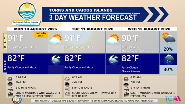
3 DAY PUBLIC WEATHER FORECAST FOR MONDAY AUGUST 10TH 2026
PUBLIC FORECAST FOR THE TURKS AND CAICOS ISLANDS FOR THE NEXT THREE DAYS FROM MONDAY AUGUST 10TH 2026
GENERAL SITUATION: A high pressure ridge and Saharan dust plume are combining to bring warm, hazy, and dry conditions across the Turks and Caicos Islands today.
SPECIAL WARNINGS: A Heat Advisory is in effect for the Turks and Caicos Islands. Residents and visitors should take the necessary precautions while outdoors during peak sunshine hours (10 am – 4 pm) and to safeguard their health as heat indices in the triple digits are anticipated.
ALL AREAS
WEATHER: Partly cloudy and hazy today.
WINDS: Easterly at 10 to 15 knots
SEAS: Slight to moderate with wave heights of 3 feet or less nearshore, building up to 5 feet offshore.
DAYTIME HIGH TEMPERATURE 91°F 33°C
HEAT INDEX 105°F 41°C
OVERNIGHT LOW TEMPERATURE 82°F 28°C
SUNSET: 07:23 PM
NEXT LOW TIDE: 12:46 PM (0.3 FT)
NEXT HIGH TIDE: 07:25 PM (3.3 FT)
EXTENDED FORECAST: Hot temperatures and gentle to moderate winds are expected to persist across the Turks and Caicos Islands throughout the work week under a deep ridge of high pressure. Rainfall chances will remain low due to a dry air mass and Saharan dust, which will contribute to hazy or milky skies and slightly reduced air quality at times. By Wednesday, an approaching tropical wave will slightly increase the chance of showers and thunderstorm activity across the islands.
TUESDAY: Partly cloudy and hazy, with a high near 91°F (33°C).
TUESDAY NIGHT: Partly cloudy and hazy, with a low around 82°F (28°C).
WINDS: Easterly at 10 to 15 knots
SEAS: Slight to moderate with wave heights of 4 feet or less
SUNRISE: 06:25 AM
SUNSET: 07:22 PM
LOW TIDE: 01:57 AM (0.7 FT) 01:44 PM (0.3 FT)
HIGH TIDE: 07:35 AM (2.3 FT) 08:16 PM (3.3 FT)
WEDNESDAY: A low (10 to 20 percent) chance of isolated showers and an isolated thunderstorm possible in the afternoon. Partly cloudy, with a high near 90°F (32°C).
WEDNESDAY NIGHT: A low (20 to 30 percent) chance of showers. Partly cloudy, with a low around 82°F (28°C).
WINDS: Easterly at 10 to 15 knots
SEAS: Slight to moderate with wave heights of 4 feet or less
SUNRISE: 06:25 AM
SUNSET: 07:21 PM
LOW TIDE: 02:45 AM (0.7 FT) 02:39 PM (0.3 FT)
HIGH TIDE: 08:29 AM (2.3 FT) 09:05 PM (3.0 FT)
TROPICAL WEATHER OUTLOOK:
Eastern and Central Tropical Atlantic: An area of low pressure located a few hundred miles south of the Cabo Verde Islands has a low chance of formation over the next two days and a medium chance of formation through seven days. A tropical depression could form during the latter half of this week while the system moves westward to west-northwestward across the central tropical Atlantic.
Central Tropical Atlantic: A broad area of showers and thunderstorms associated with a tropical wave is located about midway between the coast of west Africa and the Lesser Antilles. The system has a low chance of development through the next seven days while it moves quickly westward across the central tropical Atlantic.
Western Subtropical Atlantic: A trough of low pressure located a few hundred miles northwest of Bermuda has a low chance of formation through the next seven days while it moves eastward and into cooler waters later this week.
FORECASTER: H. HAMILTON
Audio Version:

Jamaica Delivers Spectacular Sporting Glory Across 54 Championships in 2 Months
Over the past two months, Jamaica’s track and field athletes delivered a spectacular haul of 54 medals across four major championships.
Those championships are: the Commonwealth Games, the Central American and Caribbean Games,
NACAC U23 Championships and World Athletics U20 Championships.
Team Jamaica, captured 25 gold, 17 silver, and 12 bronze medals. The extraordinary performance spanned senior, under-23, and junior competitions.
The verified medal breakdown:
Commonwealth Games
10 gold | 3 silver | 5 bronze
Total: 18 medals
NACAC U23 Championships
12 gold | 8 silver | 3 bronze
Total: 23 medals
Central American and Caribbean Games
1 gold | 3 silver | 1 bronze
Total: 5 medals
World Athletics U20 Championships
2 gold | 3 silver | 3 bronze
Total: 8 medals
Some key highlights included:
Commonwealth Games Success: Jamaica's senior team shined in Glasgow, led by historic individual performances like Samantha Hall's gold in the women's discus and Sanique Walker's personal best to win the 400m hurdles.
The Next Generation at World U20: Sprinter Shanoya Douglas anchored the women's 4x100m relay to a spectacular gold-medal victory in a world-leading U20 time of 42.89 seconds, capping off a championship where she also took two individual silvers.
Congratulations to all athletes as well as to the coaches, managers, medical teams, support staff, families and everyone working behind the scenes to prepare and support these athletes.
Great job, Team Jamaica!

Spanish Authorities Dismantle Major Criminal Network
Spanish authorities, working with international law enforcement agencies, have dismantled a major criminal network accused of trafficking migrants, drugs and weapons across the Western Mediterranean.
Europol and Spain’s Civil Guard announced the operation on Friday August 7th 2026, describing the group as one of the “largest criminal organizations specializing in maritime human trafficking in the Mediterranean.”
The investigation highlighted the sophisticated and lucrative nature of criminal networks operating across the narrow stretch of sea separating Europe and North Africa.
According to Europol, the organization provided logistical support to other criminal groups involved in smuggling activities, arranging storage, transportation, refueling, maritime transfers, vessel maintenance and counter-surveillance services.
The Hague-based European Union law enforcement agency helped coordinate the investigation, which Spanish authorities launched in 2023. The operation involved Spain’s Civil Guard and National Police, along with law enforcement agencies from France, Poland and Portugal.
The investigation culminated in a coordinated operation on June 16 that resulted in 77 arrests in Spain and one in Algeria, Europol said.
Authorities also seized 18 motorboats, including high-speed vessels, along with drugs, satellite phones, a handgun and more than 25,000 euros (US$29,000) in cash.
Video released by Spanish authorities showed officers arresting suspects and counting large quantities of 50-euro notes recovered during searches.
Investigators said the criminal network operated a two-way smuggling route between Algeria and Spain.
Spain’s Civil Guard said the organization transported drugs to Algeria before using boats on the return journey to carry migrants to coastal communities in Spain.
Four people identified by authorities as alleged leaders of the network were among those arrested.
The announcement came a week after irregular migration to Spain again drew international attention when tens of thousands of migrants entered the Spanish North African territory of Ceuta amid widespread online rumors that the border was open. Most of those migrants have since returned to Morocco.

Dominican Republic Deports More than 200,000 Haitian Nationals in 2026
Immigration officials in the Dominican Republic deported more than 226,500 Haitian nationals living in the country without legal status between January and the end of July 2026, averaging about 1,000 deportations per day, according to the country’s director general of migration.
According to officials, intelligence operations have identified Haitian-Dominican trafficking networks involved in smuggling migrants into the country.
The migration chief said authorities have identified routes, travel patterns and departure points used by the networks, and about 15 people have been arrested and are under investigation for allegedly serving as leaders or guides for the smuggling operations.
Investigators have also mapped routes used by migrants traveling on foot through various communities before reaching Santiago and other destinations within the Dominican Republic.
International humanitarian groups and local activists continue to document severe challenges stemming from the scale of the sweep. Human rights organizations have flagged repetitive instances of arbitrary detentions, systemic family separations, and a lack of individualized legal reviews during processing.
Activists accuse the administration of implementing a racially discriminatory immigration system targeting people of Haitian descent. In response, President Luis Abinader has repeatedly denied any institutional mistreatment, maintaining that operations adhere strictly to national security laws.
The Dominican government is deploying substantial capital and modern technology to permanently fortify its 240-mile border with Haiti:
* Budget & Equipment Expansion: The DGM is integrating an operational budget increase of RD$2,000 million to purchase high-mobility enforcement vehicles, hire new agents, and implement facial recognition and AI tracking tools.
* Border Wall Progress: Construction is ongoing for the multi-phase, 13-foot-high border fence originally launched in Dajabón to stem illicit crossings and disable human trafficking networks.
* Processing Facility Upgrades: To keep pace with the 1,000-per-day volume, the government is updating processing centers in Higüey, Haina, Santiago, and Elías Piña, while planning expansion facilities further south in Jimaní and Pedernales
The ongoing political and security instability inside Haiti continues to drive high migration pressures across the island.

Inaugural Trafficking in Persons Seminar Series Launched in Turks and Caicos
Human trafficking is not a distant problem confined to just larger countries, it is also a matter confronting the Turks and Caicos Islands, with cases before the courts and active investigations underway.
This morning, Monday August 10th, government officials, prosecutors, police officers and representatives from several key departments gathered for the opening of the territory’s first annual Trafficking in Persons (TIP) Seminar Series.
The two-day seminar, which is aimed at strengthening the territory’s ability to identify and protect trafficking victims, investigate suspected offences and prosecute those responsible.
The seminar is being hosted by the Office of the Director of Public Prosecutions in collaboration with the Department of Gender Affairs and the Trafficking Unit of the Royal Turks and Caicos Islands Police Force (RTCIPF).
Acting Director of Public Prosecutions Dr. Angela Brooks noted that the territory has legislation specifically addressing trafficking in persons, along with a dedicated police unit responsible for investigating the crime.
The Acting DPP identified Colombia and the Dominican Republic among countries of origin encountered in the Turks and Caicos Islands’ experienced with trafficking.
Minister of Public Safety, Gender and Religious Affairs and Social Welfare Hon. Shaun Malcolm described trafficking as one of the gravest violations of human dignity and human rights.
Because trafficking is multifaceted, he said, the Government’s response must also be comprehensive.
Hon. Malcolm said this requires strong legislation and enforcement, properly trained personnel, effective systems for identifying and protecting victims, greater public awareness and efforts to address the vulnerabilities traffickers exploit.
The first annual TIP Seminar Series is intended to strengthen that capacity by bringing prosecutors, law enforcement officers, social protection personnel and other stakeholders together around a coordinated response.
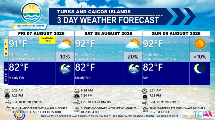
3 DAY PUBLIC WEATHER FORECAST FROM FRIDAY AUGUST 7TH 2026
PUBLIC FORECAST FOR THE TURKS AND CAICOS ISLANDS FOR THE NEXT THREE DAYS FROM FRIDAY AUGUST 07TH 2026
GENERAL SITUATION: High pressure ridging is maintaining gentle to moderate winds across the Turks and Caicos Islands today.
SPECIAL WARNINGS: No public warnings in effect at this time.
UV Index: The public are still advised to wear protective clothing and sunscreen and seek shaded areas while outside during peak sunshine hours (11am – 4pm), as UV indices are expected to be in the very high to extreme range.
ALL AREAS
WEATHER: Partly cloudy with a low (10 percent) chance of isolated showers this afternoon. Mostly fair tonight.
WINDS: East to southeast at 10 to 20 knots
SEAS: Slight to moderate with wave heights of 3 feet or less, building up to 5 feet offshore
DAYTIME HIGH TEMPERATURE 91°F 33°C
HEAT INDEX 102°F 39°C
OVERNIGHT LOW TEMPERATURE 82°F 28°C
SUNSET: 07:25 PM
NEXT HIGH TIDE: 04:25 PM (3.0 FT)
NEXT LOW TIDE: 11:06 PM (1.0 FT)
EXTENDED FORECAST: High pressure will strengthen across the region, maintaining hot and generally stable conditions through the weekend and into midweek, with little to no shower or thunderstorm activity expected across the Turks and Caicos Islands.
SATURDAY: A low (10 to 20 percent) chance of showers. Partly cloudy, with a high near 92°F (33°C).
SATURDAY NIGHT: Mostly fair, with a low around 82°F (28°C).
WINDS: East to southeast at 10 to 20 knots
SEAS: Slight to moderate with wave heights of 2 to 4 feet
SUNRISE: 06:24 AM
SUNSET: 07:24 PM
HIGH TIDE: 04:34 AM (2.0 FT) 05:29 PM (3.0 FT)
LOW TIDE: 10:41 AM (0.7 FT) - - - -
SUNDAY: Isolated showers possible. Mostly sunny, with a high near 92°F (33°C).
SUNDAY NIGHT: Fair, with a low around 82°F (28°C).
WINDS: East to southeast at 10 to 20 knots
SEAS: Slight to moderate with wave heights of 2 to 4 feet
SUNRISE: 06:24 AM
SUNSET: 07:23 PM
LOW TIDE: 12:09 AM (1.0 FT) 11:46 AM (0.3 FT)
HIGH TIDE: 05:38 AM (2.0 FT) 06:29 PM (3.0 FT)
TROPICAL WEATHER OUTLOOK: Tropical cyclone activity is not expected during the next seven (7) days.
FORECASTER: H. HAMILTON
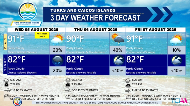
3 DAY PUBLIC WEATHER FORECAST FROM WEDNESDAY AUGUST 5TH 2026
GENERAL SITUATION: A ridge of high pressure is supporting breezy conditions and slight to moderate seas throughout the archipelago.
SPECIAL WARNINGS: The public are advised to wear protective clothing and sunscreen and seek shaded areas while outside during peak sunshine hours (11am – 4pm), as UV indices are expected to be in the very high to extreme range.
ALL AREAS
WEATHER: Partly cloudy with a low (10 to 20 percent) chance of isolated showers through tonight.
WINDS: Easterly at 10 to 15 knots
SEAS: Slight to moderate with wave heights of 3 feet or less nearshore, building up to 5 feet offshore
DAYTIME HIGH TEMPERATURE 91°F 33°C
HEAT INDEX 102°F 39°C
OVERNIGHT LOW TEMPERATURE 82°F 28°C
SUNSET: 07:26 PM
NEXT HIGH TIDE: 02:15 PM (2.6 FT)
NEXT LOW TIDE: 08:49 PM (1.0 FT)
EXTENDED FORECAST: A trough moving across the Turks and Caicos Islands on Thursday is expected to bring an increase in showers and thunderstorm activity through Friday. Conditions will improve over the weekend as high pressure strengthens, bringing a return to mostly dry and stable weather.
THURSDAY: A low (20 to 40 percent) chance of showers and isolated thunderstorms. Partly cloudy, with a high near 90°F (32°C).
THURSDAY NIGHT: Isolated showers possible. Partly cloudy, with a low around 82°F (28°C).
WINDS: East to southeast at 10 to 20 knots
SEAS: Slight to moderate with wave heights of 2 to 4 feet nearshore, building up to 6 feet offshore
SUNRISE: 06:23 AM
SUNSET: 07:25 PM
HIGH TIDE: 02:25 AM (2.0 FT) 03:19 PM (2.6 FT)
LOW TIDE: 08:34 AM (0.7 FT) 09:58 PM (1.0 FT)
FRIDAY: A low (10 percent) chance of isolated showers. Partly cloudy, with a high near 91°F (33°C).
FRIDAY NIGHT: Isolated showers possible. Mostly fair, with a low around 82°F (28°C).
WINDS: East to southeast at 10 to 15 knots
SEAS: Slight to moderate with wave heights of 3 feet or less nearshore, building up to 5 feet offshore
SUNRISE: 06:23 AM
SUNSET: 07:25 PM
HIGH TIDE: 03:28 AM (2.0 FT) 04:25 PM (3.0 FT)
LOW TIDE: 09:36 AM (0.7 FT) 11:06 PM (1.0 FT)
TROPICAL WEATHER OUTLOOK: Tropical cyclone activity is not expected during the next seven (7) days.
FORECASTER: H. HAMILTON
Audio Version:
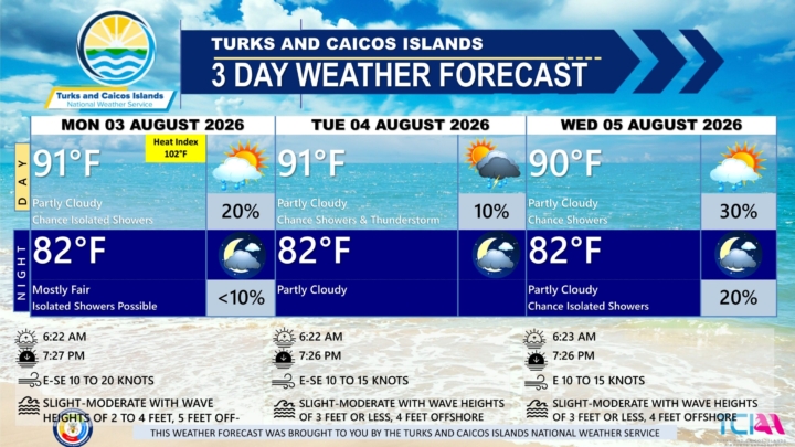
3 DAY PUBLIC WEATHER FORECAST FROM MONDAY AUGUST 3RD 2026
GENERAL SITUATION: A ridge of high pressure is maintaining generally stable and breezy conditions across the Turks and Caicos Islands today, however abundant atmospheric moisture could trigger isolated shower activity.
SPECIAL WARNINGS:
Rip currents: There is a slight to moderate risk of rip currents for the Atlantic coastal waters of the Turks and Caicos Islands.
UV Index: The public is advised to wear protective clothing and sunscreen and seek shaded areas while outside during peak sunshine hours (11am – 4pm), as UV indices are expected to be in the very high to extreme range.
ALL AREAS
WEATHER: Partly cloudy with a low (10 to 20 percent) chance of isolated showers. Mostly fair with isolated showers possible tonight.
WINDS: East to southeast at 10 to 20 knots with higher gusts
SEAS: Slight to moderate with wave heights of 2 to 4 feet, building up to 5 feet offshore
DAYTIME HIGH TEMPERATURE 91°F 33°C
HEAT INDEX 102°F 39°C
OVERNIGHT LOW TEMPERATURE 82°F 28°C
SUNSET: 07:27 PM
NEXT HIGH TIDE: 12:22 PM (2.6 FT)
NEXT LOW TIDE: 06:43 PM (1.0 FT)
EXTENDED FORECAST: By Tuesday, a tropical wave passing south of the Turks and Caicos Islands will maintain the chance of showers and thunderstorms through midweek.
TUESDAY: A low (10 percent) chance of isolated showers and a possible isolated thunderstorm. Partly cloudy, with a high near 91°F (33°C).
TUESDAY NIGHT: Partly cloudy, with a low around 82°F (28°C).
WINDS: East to southeast at 10 to 15 knots
SEAS: Slight to moderate with wave heights of 3 feet or less nearshore, building up to 4 feet offshore
SUNRISE: 06:22 AM
SUNSET: 07:26 PM
HIGH TIDE: 12:37 AM (2.3 FT) 01:16 PM (2.6 FT)
LOW TIDE: 06:48 AM (0.7 FT) 07:43 PM (1.0 FT)
WEDNESDAY: A low (20 to 30 percent) chance of showers. Partly cloudy, with a high near 90°F (32°C).
WEDNESDAY NIGHT: A low (10 to 20 percent) chance of isolated showers. Partly cloudy, with a low around 82°F (28°C).
WINDS: Easterly at 10 to 15 knots
SEAS: Slight to moderate with wave heights of 3 feet or less nearshore, building up to 4 feet offshore
SUNRISE: 06:23 AM
SUNSET: 07:26 PM
HIGH TIDE: 01:27 AM (2.0 FT) 02:15 PM (2.6 FT)
LOW TIDE: 07:38 AM (0.7 FT) 08:49 PM (1.0 FT)
TROPICAL WEATHER OUTLOOK: Tropical cyclone activity is not expected during the next seven (7) days.
FORECASTER: H. HAMILTON