
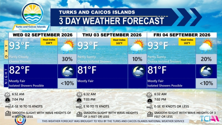
3 DAY PUBLIC WEATHER FORECAST FROM WEDNESDAY SEPTEMBER 2ND 2026
PUBLIC FORECAST FOR THE TURKS AND CAICOS ISLANDS FOR THE NEXT THREE DAYS FROM WED 02ND SEPTEMBER 2026
GENERAL SITUATION: A broad ridge of high pressure is keeping conditions generally settled across the Turks and Caicos Islands today. However, lingering moisture in the atmosphere could trigger isolated showers, particularly during the afternoon.
ALL AREAS
WEATHER: Partly cloudy with a low (10 to 30 percent) chance of isolated showers this afternoon. Mostly fair with isolated showers possible tonight.
WINDS: East to southeast at 10 to 15 knots
SEAS: Smooth to slight with wave heights of 4 feet or less
DAYTIME HIGH TEMPERATURE 93°F 34°C
HEAT INDEX 104°F 40°C
OVERNIGHT LOW TEMPERATURE 82°F 28°C
SUNSET: 07:04 PM
NEXT HIGH TIDE: 12:03 PM (2.6 FT)
NEXT LOW TIDE: 06:30 PM (1.0 FT)
EXTENDED FORECAST: Settled conditions are expected to persist through the period, with lingering moisture keeping the chance of isolated afternoon showers in the forecast.
THURSDAY: A low (10 percent) chance of isolated showers with possible afternoon thunderstorm. Partly sunny, with a high near 93°F (34°C).
THURSDAY NIGHT: Mostly fair, with a low around 81°F (27°C).
WINDS: Easterly at 10 to 15 knots
SEAS: Smooth to slight with wave heights of 3 feet or less
SUNRISE: 06:32 AM
SUNSET: 07:03 PM
HIGH TIDE: 12:12 AM (2.3 FT) 12:57 PM (3.0 FT)
LOW TIDE: 06:21 AM (0.7 FT) 07:28 PM (1.0 FT)
FRIDAY: A low (10 to 20 percent) chance of isolated showers with possible afternoon thunderstorm. Partly sunny, with a high near 93°F (34°C).
FRIDAY NIGHT: Isolated showers possible. Mostly fair, with a low around 81°F (27°C).
WINDS: East to southeast at 10 knots or less
SEAS: Smooth to slight with wave heights of 3 feet or less
SUNRISE: 06:32 AM
SUNSET: 07:02 PM
HIGH TIDE: 01:03 AM (2.0 FT) 01:56 PM (3.0 FT)
LOW TIDE: 07:13 AM (0.7 FT) 08:31 PM (1.0 FT)
TROPICAL WEATHER OUTLOOK:
The National Hurricane Center has issued its final advisory on Tropical Depression Edouard that is located inland over southeastern Texas.
Tropical cyclone formation is not expected during the next 7 days.


John Ternus Takes the Helm at Apple, from Tim Cook after 15 Years
Apple’s new CEO, John Ternus, takes charge of the technology giant Tuesday, bringing Tim Cook’s 15-year tenure to an end. Under Cook, Apple’s value soared to roughly $4.6 trillion, fueled largely by the continued popularity of the iPhone.
Ternus assumes leadership at a critical moment for Apple. The rapid rise of artificial intelligence has triggered the biggest disruption in the technology industry since Steve Jobs introduced the first iPhone in 2007. Apple has struggled to keep pace, particularly after delays and setbacks in delivering AI-powered features that it first promised nearly two years ago.
Earlier this year, Apple announced a new wave of AI improvements, including upgrades to its Siri voice assistant. The company has emphasized privacy and practical, everyday applications as it works to close the gap with competitors that have moved more aggressively into artificial intelligence.
For Ternus, the challenges extend well beyond his background in hardware engineering. He will be expected to strengthen Apple’s position in the AI race while also managing complex supply-chain issues and maintaining relationships with influential political figures, including President Donald Trump, who publicly praised Cook on Tuesday.
Those relationships could prove particularly important. During his time as CEO, Cook developed a close working relationship with Trump while steering Apple through major business challenges, including the administration’s trade policies and tariffs affecting countries in Asia, where much of Apple’s manufacturing supply chain is based. Although Cook is stepping down as CEO, he is expected to help Apple maintain those ties with Trump in his new role as executive chairman.
Ternus is no stranger to Apple’s most important products. During Cook’s tenure, he played key roles in the development of products including the Apple Watch, AirPods and Apple Vision Pro.
His first major public test as CEO will come next week, when he is expected to lead the launch of Apple’s latest iPhone at the company’s headquarters in Cupertino, California.
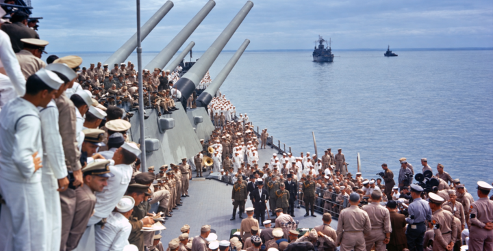
September 2nd, Anniversary of End of World War II
September 2 marks the anniversary of the formal end of World War II, the devastating global conflict that reshaped nations, claimed tens of millions of lives and fundamentally altered the course of modern history.
On September 2, 1945, representatives of Japan and the Allied Powers gathered aboard the battleship USS Missouri in Tokyo Bay to sign the Instrument of Surrender, formally bringing World War II to an end.
The historic ceremony came more than six years after Germany’s invasion of Poland in September 1939 triggered war in Europe and nearly four years after the Japanese attack on Pearl Harbor brought the United States directly into the conflict.
Japan had announced its acceptance of the Allied terms of surrender on August 15, 1945, a date widely commemorated as Victory over Japan. However, it was the signing of the formal surrender documents on September 2 that officially and legally ended the war.
The ceremony aboard the USS Missouri was brief, lasting approximately 23 minutes, but its significance was enormous.
Japanese Foreign Minister Mamoru Shigemitsu signed the Instrument of Surrender on behalf of the Japanese government, while General Yoshijiro Umezu signed on behalf of Japan’s armed forces.
General Douglas MacArthur, Supreme Commander for the Allied Powers, signed on behalf of the Allied nations before representatives of other Allied countries added their signatures to the historic document.
The selection of the USS Missouri as the site of the surrender carried additional symbolism. The battleship was named after the home state of U.S. President Harry S. Truman, who had assumed the presidency following the death of Franklin D. Roosevelt in April 1945.
The surrender brought to a close the deadliest conflict in human history.
World War II engulfed much of the globe, devastated cities and communities and resulted in the deaths of tens of millions of military personnel and civilians.
The end of the war ushered in a dramatically different international order. The United Nations was established in 1945 with the goal of promoting international cooperation and preventing another global conflict, while the United States and Soviet Union emerged as rival superpowers in what would become the Cold War.
Eighty-one years after the surrender aboard the USS Missouri, September 2 remains a date for both remembrance and reflection.

20-Year-Old Haitian High School Graduate Dies by Suicide After Losing Temporary Protected Status
A 20-year-old Haitian immigrant who had recently graduated from high school and lost his Temporary Protected Status died by suicide Monday, according to an advocacy group representing his family.
Pierre Damas Bel came to the United States in 2024 to reunite with his parents, who had fled Haiti.
On Monday, Bel stopped his vehicle along Interstate 70 in Springfield, Ohio, got out and entered traffic, according to law enforcement officials cited by local news outlets.
The Ohio State Highway Patrol told ABC News that Bel’s death remains under investigation.
In a statement, the agency said Bel parked his Toyota along the interstate, exited the vehicle and entered the highway’s westbound lanes.
Bel was among more than 350,000 Haitian immigrants who lost Temporary Protected Status after the U.S. Supreme Court in June cleared the way for the Trump administration to terminate the protections. TPS allows eligible immigrants from countries experiencing conditions such as armed conflict or natural disasters to temporarily remain and work in the United States without being deported.
Bel had also recently been fitted with a GPS ankle monitor by the Department of Homeland Security, according to posts on his social media account.
Before his death, Bel had been building a life in Springfield. He played varsity soccer at Springfield High School and earned the rank of lieutenant in the school’s Junior Reserve Officers’ Training Corps. He had also planned to attend Wright State University in Ohio in the fall.
Letters posted to Bel’s Instagram account show that his high school teachers, JROTC military leader and employers at Texas Roadhouse had recently written to the judge overseeing his immigration case. The letters described Bel’s character and accomplishments as he pursued a path toward remaining legally in the United States.
His death comes amid broader changes to U.S. immigration policy affecting Haitians. Since ending TPS protections for Haitians, the Trump administration has sent two deportation flights to Haiti as part of its wider immigration enforcement campaign.
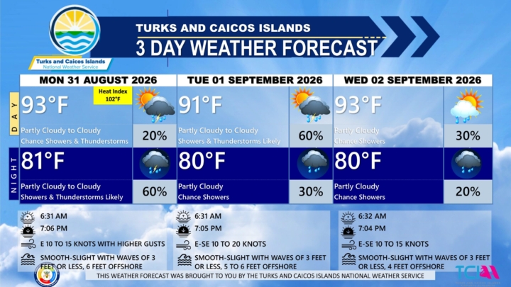
3 DAY PUBLIC WEATHER FORECAST FROM MONDAY 31ST AUGUST 2026
GENERAL SITUATION: A surface trough east of the Turks and Caicos Islands is producing scattered showers and thunderstorms over the surrounding waters, with conditions expected to deteriorate as the system approaches the islands later today.
ALL AREAS
WEATHER: Partly cloudy to cloudy with a low (10 to 20 percent) chance of isolated showers or isolated thunderstorm today, then a medium (40 to 60 percent) chance of scattered showers and isolated thunderstorms tonight, mainly after 11 pm. New rainfall accumulation between a tenth to a quarter of an inch.
WINDS: Easterly at 10 to 15 knots with gusts up to near gale force
SEAS: Smooth to slight with wave heights of 3 feet or less nearshore, building up to 6 feet offshore
DAYTIME HIGH TEMPERATURE 93°F 34°C
HEAT INDEX 102°F 39°C
OVERNIGHT LOW TEMPERATURE 81°F 27°C
SUNSET: 07:06 PM
NEXT LOW TIDE: 05:36 PM (0.7 FT)
NEXT HIGH TIDE: 11:26 PM (2.3 FT)
EXTENDED FORECAST: The trough will move across the Turks and Caicos Islands on Tuesday, bringing periods of showers and thunderstorms and increasing the risk of flooding. The system is expected to move quickly through the area, with strong upper-level winds preventing any tropical development over the next day or two.
TUESDAY: A medium (40 to 60 percent) chance of scattered showers and isolated thunderstorms in the morning, then a low (10 to 20 percent) chance of isolated showers in the afternoon. Partly cloudy to cloudy, with a high near 91°F (33°C).
TUESDAY NIGHT: A low (10 to 30 percent) chance of widely scattered showers. Partly cloudy, with a low around 80°F (27°C). New rainfall accumulation between a tenth to a quarter of an inch.
WINDS: East to southeast at 10 to 20 knots with occasional gusts
SEAS: Smooth to slight with wave heights of 3 feet or less nearshore, building up to 5 to 6 feet offshore
SUNRISE: 06:31 AM
SUNSET: 07:05 PM
LOW TIDE: 04:35 AM (0.7 FT) 06:30 PM (1.0 FT)
HIGH TIDE: 12:03 PM (3.0 FT) - - - -
WEDNESDAY: A low (10 to 30 percent) chance of isolated showers. Partly cloudy, with a high near 93°F (34°C).
WEDNESDAY NIGHT: A low (10 to 20 percent) chance of isolated showers. Partly cloudy, with a low around 80°F (27°C). New rainfall accumulation of about a tenth of an inch.
WINDS: East to southeast at 10 to 15 knots
SEAS: Smooth to slight with wave heights of 3 feet or less nearshore, building up to 4 feet offshore
SUNRISE: 06:32 AM
SUNSET: 07:04 PM
HIGH TIDE: 12:12 AM (2.3 FT) 12:57 PM (3.0 FT)
LOW TIDE: 06:21 AM (0.7 FT) 07:28 PM (1.0 FT)
TROPICAL WEATHER OUTLOOK:
1. Northern Gulf of America (AL97): An area of low pressure located a little more than 100 miles south of the coast of southern Louisiana continues to produce a small but concentrated area of showers and thunderstorms with some signs of organization. There is a high chance that a short-lived tropical depression or tropical storm is likely to form before the system reaches the Upper Texas or southwestern Louisiana coasts on Tuesday.
2. Near Hispaniola (Remnants of Dolly): A surface trough of low pressure (the remnants of Tropical Storm Dolly) is producing a disorganized area of showers and thunderstorms that extends from near Hispaniola eastward to the northern Leeward Islands. Redevelopment, if any, would be slow to occur during the next few days as the system encounters generally unfavorable upper-level winds while moving quickly west-northwestward at 20 to 25 mph. Regardless, the system could bring locally heavy rains and gusty winds to portions of the Leeward Islands, the Virgin Islands, Puerto Rico, Hispaniola, and the Bahamas during the next couple of days. This system has a low chance of development in the next 7 days.
FORECASTER: H. HAMILTON
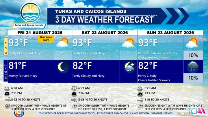
3 DAY PUBLIC WEATHER FORECAST FROM FRIDAY AUGUST 21ST 2026
GENERAL SITUATION: Weak high pressure ridging and an incoming plume of Saharan dust will maintain hot, dry, and stable conditions across the Turks and Caicos Islands today.
SPECIAL WARNINGS:
A Heat Advisory remains in effect for the Turks and Caicos Islands.
A Dust Advisory is now in effect for the Turks & Caicos Islands through Saturday. The level of dust is expected to reach moderate levels by early afternoon which may impact air quality and hinder visibility at times. Residents, especially those with respiratory illnesses, should take precautions to safeguard their health.
AREA: ALL AREAS
WEATHER: Partly cloudy and hazy. Mostly fair tonight.
WINDS: East to southeast at 10 to 20 knots
SEAS: Smooth to slight with wave heights of 3 feet or less nearshore, building up to 4 feet offshore
DAYTIME HIGH TEMPERATURE 93°F 34°C
HEAT INDEX 108°F 42°C
OVERNIGHT LOW TEMPERATURE 81°F 27°C
SUNSET: 07:15 PM
NEXT HIGH TIDE: 04:31 PM (2.6 FT)
NEXT LOW TIDE: 11:14 PM (1.3 FT)
EXTENDED FORECAST: Dry and settled conditions are expected to persist across the Turks and Caicos Islands heading into the weekend, as high pressure and drier air dominate the area.
SATURDAY: Partly cloudy and hazy, with a high near 93°F (34°C).
SATURDAY NIGHT: Partly cloudy and hazy, with a low around 82°F (28°C).
WINDS: East to southeast at 10 to 20 knots
SEAS: Smooth to slight with wave heights of 3 feet or less nearshore, building up to 4 feet offshore
SUNRISE: 06:29 AM
SUNSET: 07:14 PM
HIGH TIDE: 04:39 AM (2.0 FT) 05:23 PM (2.6 FT)
LOW TIDE: 10:35 AM (1.0 FT) - - - - -
SUNDAY: A low (10 percent) chance of isolated showers. Partly cloudy and a bit hazy, with a high near 93°F (34°C).
SUNDAY NIGHT: A low (10 percent) chance of isolated showers. Partly cloudy, with a low around 82°F (28°C).
WINDS: Easterly at 10 to 20 knots
SEAS: Smooth to slight with wave heights of 3 feet or less nearshore, building up to 4 feet offshore
SUNRISE: 06:29 AM
SUNSET: 07:13 PM
LOW TIDE: 12:01 AM (1.3 FT) 11:26 AM (1.0 FT)
HIGH TIDE: 05:28 AM (2.0 FT) 06:11 PM (2.6 FT)
TROPICAL WEATHER OUTLOOK:
There are two areas of interest in the Atlantic Basin:
1. Northeastern Atlantic: A non-tropical area of low pressure has developed over the northeastern Atlantic several hundred miles north-northeast of the Azores. This system could acquire some subtropical or tropical characteristics on Saturday or early Sunday while it moves east-southeastward at 10 to 15 mph toward Portugal and northwestern Spain. This system has a low (20 percent) chance of formation during the next 7 days.
2. Central Subtropical Atlantic: A weak area of low pressure located over the central subtropical Atlantic a few hundred miles east-southeast of Bermuda is producing an area of disorganized showers and thunderstorms. This system has a low (20 percent) chance of formation during the next 7 days.
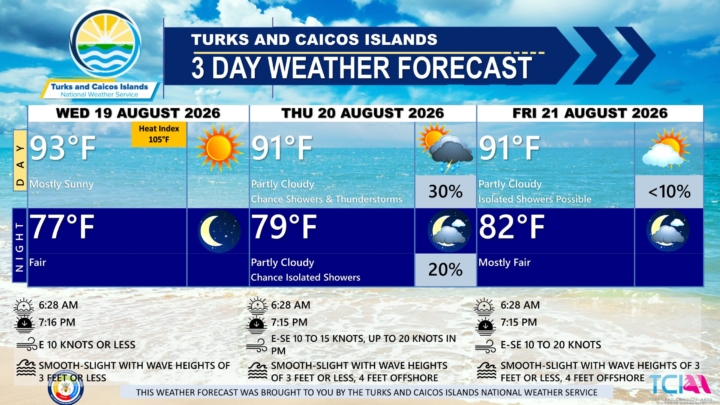
3 DAY PUBLIC WEATHER FORECAST FROM WEDNESDAY AUGUST 19TH 2026
PUBLIC FORECAST FOR THE TURKS AND CAICOS ISLANDS FOR THE NEXT THREE DAYS FROM WEDNESDAY THE 19TH OF AUGUST 2026
GENERAL SITUATION: A ridge of high pressure will maintain hot and stable conditions across the Turks and Caicos Islands today.
SPECIAL WARNINGS: A Heat Advisory is now in effect for the Turks and Caicos Islands. Expect heat indices to reach up to 108⁰F. Residents and visitors are urged to remain hydrated, seek shaded areas, and wear cool, loose-fitting clothing during peak sunshine hours (11 am – 4 pm).
AREA: ALL AREAS
WEATHER: Mostly sunny today. Fair tonight.
WINDS: Easterly at 10 knots or less
SEAS: Smooth to slight with wave heights of 3 feet or less
DAYTIME HIGH TEMPERATURE 93°F 34°C
HEAT INDEX 105°F 41°C
OVERNIGHT LOW TEMPERATURE 77°F 25°C
SUNSET: 07:16 PM
NEXT HIGH TIDE: 02:39 PM (2.6 FT)
NEXT LOW TIDE: 09:19 PM (1.0 FT)
EXTENDED FORECAST: On Thursday, a tropical wave is expected to increase the chances of shower and thunderstorm activity over portions of the Turks and Caicos Islands as it treks northwestward. By Friday, another plume of Saharan dust is expected to move into the area, limiting shower activity once again.
THURSDAY: A low (10 to 30 percent) chance of isolated showers and isolated thunderstorms in the afternoon. Partly cloudy, with a high near 91°F (33°C).
THURSDAY NIGHT: A low (10 to 20 percent) chance of isolated showers. Partly cloudy, with a low around 79°F (27°C).
WINDS: East to southeast at 10 to 15 knots, increasing up to 20 knots in the evening.
SEAS: Smooth to slight with wave heights of 3 feet or less, building up to 4 feet offshore.
SUNRISE: 06:28 AM
SUNSET: 07:15 PM
HIGH TIDE: 02:49 AM (2.0 FT) 03:45 PM (2.6 FT)
LOW TIDE: 08:48 AM (1.0 FT) 10:19 PM (1.0 FT)
FRIDAY: Isolated showers possible. Partly cloudy, with a high near 91°F (33°C).
FRIDAY NIGHT: Mostly fair, with a low around 82°F (28°C).
WINDS: East to southeast at 10 to 20 knots in the evening.
SEAS: Smooth to slight with wave heights of 3 feet or less, building up to 4 feet offshore.
SUNRISE: 06:28 AM
SUNSET: 07:15 PM
HIGH TIDE: 03:45 AM (2.0 FT) 04:31 PM (2.6 FT)
LOW TIDE: 09:42 AM (1.0 FT) 11:14 PM (1.2 FT)
TROPICAL WEATHER OUTLOOK: Tropical cyclone activity is not expected during the next 7 days.
FORECASTER: H.HAMILTON
AUDIO VERSION IS BELOW:
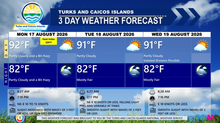
3 DAY PUBLIC WEATHER FORECAST FROM MONDAY AUGUST 17TH 2026
PUBLIC FORECAST FOR THE TURKS AND CAICOS ISLANDS FOR THE NEXT THREE DAYS FROM MONDAY AUGUST 17TH 2026
GENERAL SITUATION: High pressure ridging and Saharan dust will continue to maintain dry, hazy conditions across the Turks and Caicos Islands today.
SPECIAL WARNINGS:
A Dust Advisory remains in effect for the Turks & Caicos Islands through this evening. Low to moderate levels of dust are expected today, which may impact air quality and hinder visibility at times. Residents, especially those with respiratory illnesses, should take precautions to safeguard their health.
Rip currents: There is a high risk of rip currents along eastern and southern shorelines and along Atlantic exposed beaches. Beachgoers and swimmers are strongly advised to refrain from entering the waters in those areas.
UV Index: The public is advised to wear protective clothing and sunscreen and seek shaded areas while outside during peak sunshine hours (11am – 4pm), as UV indices are expected to be in the very high to extreme range today.
ALL AREAS
WEATHER: Partly cloudy and a bit hazy through tonight.
WINDS: Northeast to east at 10 to 15 knots
SEAS: Slight to moderate with wave heights of 3 feet or less nearshore, building up to 4 feet offshore
DAYTIME HIGH TEMPERATURE 92°F 33°C
HEAT INDEX 104°F 39°C
OVERNIGHT LOW TEMPERATURE 82°F 28°C
SUNSET: 07:18 PM
NEXT HIGH TIDE: 12:50 PM (2.6 FT)
NEXT LOW TIDE: 07:16 PM (1.0 FT)
EXTENDED FORECAST: High pressure ridging and lingering Saharan dust will maintain generally stable conditions until late Thursday or early Friday, when an approaching tropical wave is expected to enhance shower activity across the islands.
TUESDAY: Partly cloudy, with a high near 91°F (32°C).
TUESDAY NIGHT: Mostly fair, with a low around 82°F (28°C).
WINDS: Northeast to east at 10 knots or less, falling light and variable at times
SEAS: Smooth to slight with wave heights of 3 feet or less
SUNRISE: 06:27 AM
SUNSET: 07:17 PM
HIGH TIDE: 01:01 AM (2.3 FT) 01:43 PM (2.6 FT)
LOW TIDE: 07:09 AM (0.7 FT) 08:17 PM (1.0 FT)
WEDNESDAY: Isolated showers possible. Partly cloudy, with a high near 91°F (32°C).
WEDNESDAY NIGHT: Mostly fair, with a low around 82°F (28°C).
WINDS: Easterly at 10 knots or less
SEAS: Smooth to slight with wave heights of 3 feet or less
SUNRISE: 06:28 AM
SUNSET: 07:16 PM
HIGH TIDE: 01:54 AM (2.0 FT) 02:39 PM (2.6 FT)
LOW TIDE: 07:57 AM (1.0 FT) 09:19 PM (1.0 FT)
TROPICAL WEATHER OUTLOOK: Tropical cyclone activity is not expected during the next 7 days.
FORECASTER: H. HAMILTON
Audio Version Below:

Financially Speaking Host Drexwell Seymour Speaks with Hon. E. Jay Saunders
On a recent episode of RTC's Financially Speaking, Minister with Responsibility for Water Undertaking addressed the challenges in both Salt Cay and Grand Turk. Our Danae Dennie has the story.
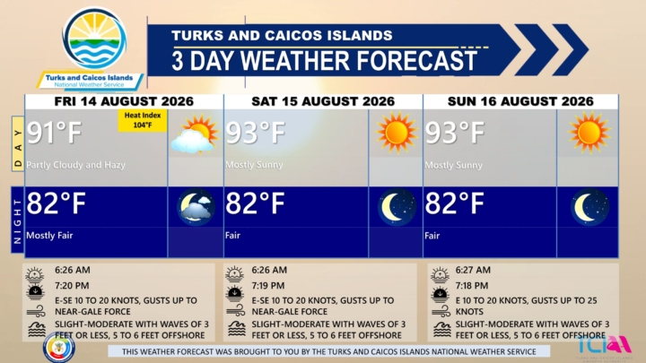
3 DAY PUBLIC WEATHER FORECAST FROM FRIDAY AUGUST 14TH 2026
PUBLIC FORECAST FOR THE TURKS AND CAICOS ISLANDS FOR THE NEXT THREE DAYS FROM FRIDAY AUGUST 14TH 2026
GENERAL SITUATION: High pressure ridging across the Turks and Caicos Islands is maintaining warm, stable, and breezy conditions, as Saharan dust limits shower activity today.
SPECIAL WARNINGS:
Rip Currents: There is a high risk of rip currents along eastern and southern shorelines and Atlantic exposed beaches. Beachgoers and swimmers in these areas should refrain from entering waters in those areas.
UV Index: Members of the public are advised to wear protective clothing and sunscreen and seek shaded areas while outside during peak sunshine hours (11am – 4pm), as UV indices are expected to be in the very high to extreme range.
ALL AREAS
WEATHER: Partly cloudy and hazy with isolated showers possible today. Mostly fair tonight.
WINDS: East to southeast at 10 to 20 knots, gusting up to near-gale force (28 to 33 knots)
SEAS: Slight to moderate with wave heights of 3 feet or less nearshore, building up to 5 to 6 feet offshore
DAYTIME HIGH TEMPERATURE 91°F 33°C
HEAT INDEX 104°F 40°C
OVERNIGHT LOW TEMPERATURE 82°F 28°C
SUNSET: 07:20 PM
NEXT LOW TIDE: 03:27 PM (0.7 FT)
NEXT HIGH TIDE: 10:38 PM (3.0 FT)
EXTENDED FORECAST: High pressure ridging will build across the Turks and Caicos Islands through the weekend and into next week, bringing hot and mostly stable conditions.
SATURDAY: Mostly sunny, with a high near 93°F (34°C).
SATURDAY NIGHT: Fair, with a low around 82°F (28°C).
WINDS: East to southeast at 10 to 20 knots with gusts up to near-gale force (28 to 33 knots)
SEAS: Slight to moderate with wave heights of 3 feet or less nearshore, building up to 5 to 6 feet offshore, and increasing to 7 to 8 feet in the evening
SUNRISE: 06:26 AM
SUNSET: 07:19 PM
LOW TIDE: 04:57 AM (0.7 FT) 05:21 PM (0.7 FT)
HIGH TIDE: 11:05 AM (2.6 FT) 11:25 PM (2.6 FT)
SUNDAY: Mostly sunny, with a high near 93°F (34°C).
SUNDAY NIGHT: Fair, with a low around 82°F (28°C).
WINDS: Easterly at 10 to 20 knots with gusts up to 25 knots
SEAS: Slight to moderate with wave heights of 3 feet or less nearshore, building up to 5 to 6 feet offshore
SUNRISE: 06:27 AM
SUNSET: 07:18 PM
LOW TIDE: 05:40 AM (0.7 FT) 06:17 PM (0.7 FT)
HIGH TIDE: 11:57 AM (2.6 FT) - - - -
TROPICAL WEATHER OUTLOOK:
1. Central Tropical Atlantic (AL92): A tropical wave located about 400 miles east of the Windward Islands is producing gusty winds and a large area of showers and thunderstorms. This system is moving into a region of increasing upper-level winds and dry air, and the potential of development continues to decrease. The system has a low chance of tropical cyclone formation in the next 48 hours.
2. Eastern Tropical Atlantic (AL94): A tropical wave over the central tropical Atlantic, located more than 1000 miles west of the Cabo Verde Islands, continues to produce disorganized showers and thunderstorms. A tropical depression could form this weekend or early next week while the wave moves westward or west-northwestward across the central tropical Atlantic. This system has a low chance of tropical cyclone formation in the next 48 hours and a medium chance in the next 7 days.
FORECASTER: H. HAMILTON
Audio Version: